Case Studies
Wandsworth Riverside Quarter
Grid Reference TQ2544975300
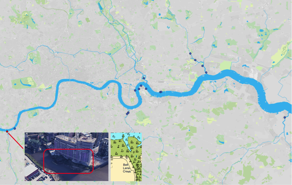
Figure 1: Map of Estuary edges sites pinpointing Wandsworth Riverside Quarter, inset graphics include Google Earth aerial photo of site and chart extract of Site (heights in metres relative to Chart Datum).
1. Introduction
1.1 Site Conditions Summary
| Salinity (during low fluvial flows) | ~1‰ (Wade, Hawes and Mulder, 2017) |
| Date of construction | 2008 |
| Tidal Range | 5.8m |
| Percentage of area accreted above design level | 88% |
| Degree of exposure to waves: | Medium |
| Degree of exposure to currents: | Medium |
| Max wave height | |
| Slope direction | East-North Easterly |
| Slope angle | 1 in 10 at steepest, 1 in 20 as shallowest. |
| Average Whole Structure lifespan | <20 years |
Table 1: Site conditions summary.
1.2 Site Characteristics
- Here the estuary is typically less than 1‰ of the salinity of seawater, but true saltmarsh plant species are known to occur in places.
- Located directly at the mouth of the River Wandle (tidal tributary) and facing into the upper Thames estuary resulting in medium wave energy from vessel generated waves and medium currents from fluvial flows in the Wandle.
- The River Wandle runs almost entirely through urban south London and (its source is near Croydon) making it ‘flashy’ in its discharge.
- The Thames beyond is used by both commercial inland vessels as well as recreational users. Predominantly the recreational use is rowers, kayakers as well as motorboats.
- Outside of the meander bend of the Thames resulting in some currents being felt here from the larger watercourse.
- Limited wind waves due to angle of slope facing East-North-East.
- In 2017 a half-tide weir was removed directly adjacent to the terraces with significant dredging beforehand to remove the accreted sediment behind. It is possible some environmental adjustment continues since this work.
- Construction of residential flats backing this site should soon be finished (time of writing March 2019) meaning that the Thames path will pass by and it will be overlooked by flats.
1.3. What the developers did
- Installed a new sheet steel pile flood defence wall approximately 17m further landward of the original line and capped the new line with concrete.
- Truncated the old fronting sheet steel pile wall sloping downwards towards the Thames and capped with timber. Rip rap placed in front of and behind the most ‘seaward’ end of this piling to provide additional protection from scour and engineering certainty to this older defence.
- Installed approximately 7 terraces out of hardwood (timber immediately backed by rock rolls) which run at an approximately 45 degree angle to the site. All terraces coincide with the height of the fronting truncated pile allow a width of foreshore of approximately 2m (Figure 3) without vertical walls thereby allowing bottom dwelling fish to utilise these areas.
- Approximately 1/3rd of the terraces are actually above normal high tide levels and are therefore terrestrial. Boxes drilled with holes of varying sizes (ideal for bees and other insect life) were installed here.
- The terraces were filled with gravel.
- Pre-planting was conducted.
- A monitoring regime of fixed point photography does exist for this site.
2. Aerial photo and as-built drawings: plan view and cross-sectional view
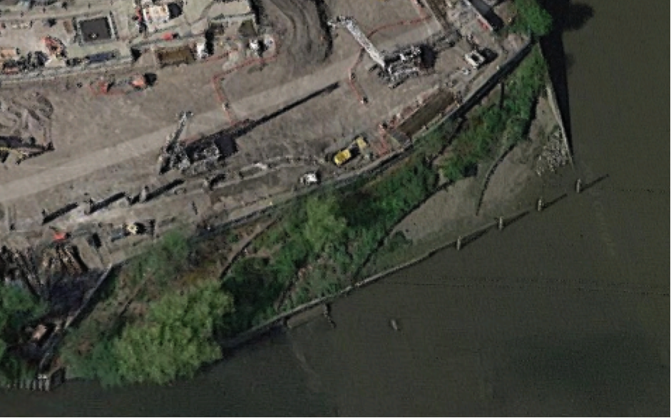
Figure 2: Aerial view of site (Google 3D image from 2018)
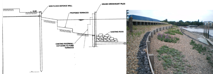
Figure 3: Section view from as-built drawings (left) and comparable photograph shortly after construction (right).
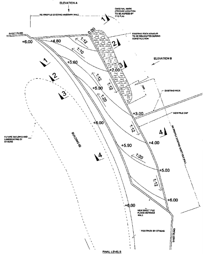
Figure 4: Plan view from as built drawings.
3. Environmental
3.1 Inundation
The immediate area of the river in front of the terraces, and up the creek dries during most tides and is a low energy flows.
During larger tides (spring) the lower terraces have water on them for over seven and half hours while the top of the terrace is rarely covered. During smaller (neap) tides the terrace has water on it for seven hours and the top of the terrace is not reached.

Figure 5: cross section of elevation of constructions (heights in Chart Datum).
3.2 Biodiversity
Adjacent Site:
This site is a few hundred metres west of Battersea Reach and is of comparable size. The fluid dynamics and water chemistry should be equally comparable.
Fish:
The terraces at Wandsworth Riverside Quarter, on the mouth of the River Wandle, provide an excellent gradient with mature vegetation which should have seen the capture of many more fish. However, very few fish were caught here in comparison to most other sites (although were similar to nearby Battersea Reach). No foreshore survey was possible on the day of the survey. Species found included Bass (Dicentrarchus labrax) and Common Goby (Pomatoschistus microps). Factors believed to contribute to the lack of diversity include:
- Disturbed quality of the silt due to previous construction and dredging from weir removal in 2017
- Impacted state of gravel on site
Botany:
A range of herbaceous plants and tree saplings accompanied the original build of the site in 2009. Willows (Salix spp.) remain from the saplings along with older vegetation that was unable to be surveyed. The lowers terraces have little plant growth, other than algae, due to river currents. The upper terraces housed species such as flag iris (Iris pseudacorus) and willow scrub brambles (Salix purpurea). Invasive non-native species (INNS) also reside on the site. These include: buddleia (Buddleja davidii), Himalayan balsam (Impatiens balsamifera), orange balsam (Impatiens capensis) and Australian swamp stonecrop (Crassula helmsii). Most concerning of these species is the Australian swamp stonecrop, as it is not usually found in tidal habitats along the Thames. It is important to continue monitoring these species for continued growth as well as possible erosion effects they are known to cause. Over 60 flowering plants were recorded on the site, some these including: gypsywort (Lycopus europaeus), bristly oxtongue (Helminthotheca echiodes) and marsh woundwort (Stachys palustris). For details of all species recorded, please see the botany report 2017. Links in the Further Reading section.
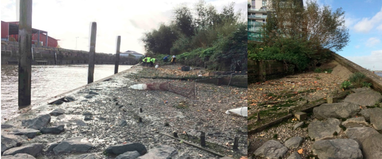
Figure 6: Wandsworth Riverside Quarter. Lower terraces largely gravel and open mud/silt. The right-hand image shows isolated patches of algae and vascular plants (including a purple willow sapling), in between the boulders are clumps of Australian swamp stonecrop.
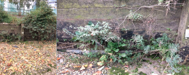
Figure 7: Wandsworth Riverside Quarter. Views from lower terrace towards middle/upper terraces, terrace wall vegetated with buddleia, willow saplings and a diverse community of herbaceous plants including broad-leaved dock and pellitory-of-the-wall.
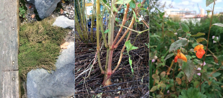
Figure 8: Wandsworth Riverside Quarter. Left to right: Australian swamp stonecrop amongst boulders on lower terraces, Himalayan balsam stems and bare earth, orange balsam growing alongside Himalayan balsam (in the background).
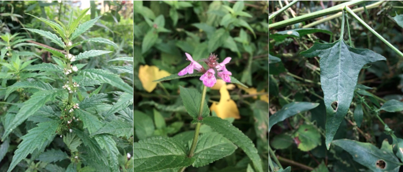
Figure 9: Wandsworth Riverside Quarter. Left to right: gypsywort, marsh woundwort, spear-leaved orache.
| Planted | Natural Colonised | Non-native | Dominant | Notable species |
| willow scrub brambles (Salix purpurea) | gypsywort (Lycopus europaeus) | buddleia (Buddleja davidii) | Australian swamp stonecrop (Crassula helmsii) | |
| bristly oxtongue (Helminthotheca echiodes) | Himalayan balsam (Impatiens balsamifera) | |||
| marsh woundwort (Stachys palustris) | orange balsam (Impatiens capensis) | |||
| flag iris (Iris pseudacorus) | Australian swamp stonecrop (Crassula helmsii) |
|
Table 2: Showing the planted, assumed naturally colonised, dominant and notable species found at the site. For full details of all species recorded, see the botany report 2017.
Invertebrates:
The habitat was Littoral sediment (LS.) and Circalittorial rock (CR). The invertebrate assemblage for this site presents a very confused result with 3 matching habitats found by the AMBIC system, one of which are within the Littoral sediment (Ls) classification and two are within the Circalittorial rock (CR) (Figure 10). This may be due to the rip rap placed on the lower terrace towards the Thames i.e. rock. However, as no singular habitat type from the Joint Nature Conservation Committee classification system can be concluded upon, this does imply that this site has failed to evolve and therefore is doing poorly.
Figure 10: Joint Nature Conservation Committee classification system possible codes for the habitat based on the invertebrate assemblage.
3.3 Geomorphology
A large 88% of the accretable area (below high tide level) has accreted with sediment above the design level (Figure 10).

Figure 10: Schematic showing geomorphology and basic ecology.
Contributing reasons for this include:
- Shallow slope.
- Not fully open to the upper estuary (tidal tributary) and thereby protected from vessel generated waves.
- Not facing into the prevailing wind (south-south-westerly).
The only areas which haven’t accreted are on rip rap which is significantly protruding above the normal mudflat surface and the area behind the collapsed piles to the southern end of the site.
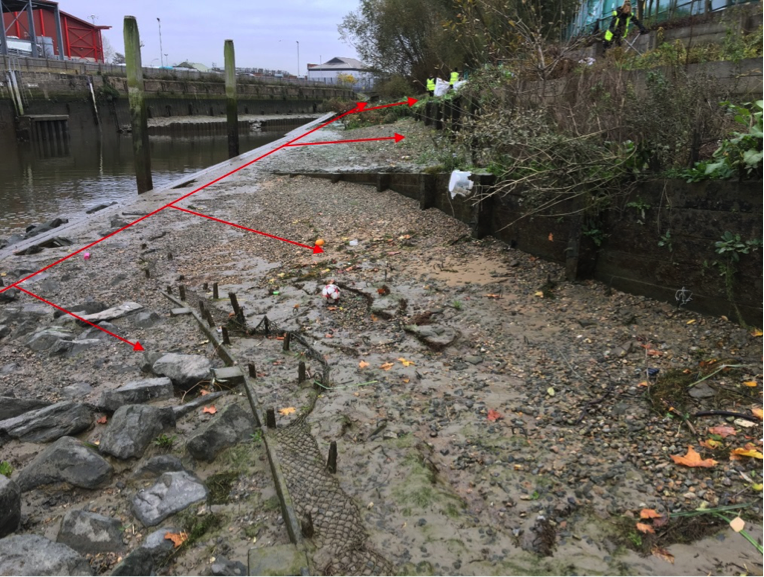
Figure 11: Wandsworth Riverside Quarter: Good sediment accretion on terraces designed to allow bottom dwelling fish a route to all surfaces without crossing vertical walls (red arrows), Spring 2018 (10 years since construction), photograph looking southerly up the Wandle. Source: Environment Agency.
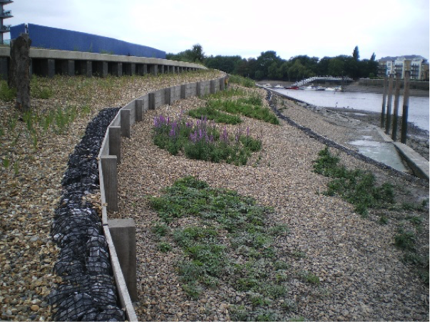
Figure 12: Wandsworth Riverside Quarter: Looking northerly towards the Thames shortly after construction in 2008 (season unknown). Showing gravel infill yet to accrete with estuarine mud and planted flora. Source: Environment Agency.

Figure 13: Wandsworth Riverside Quarter: Comparable images to Figure 12 but taken in winter/spring 2018 showing vegetation spread (somewhat uncontrollably) and general success of the terrace. Source: Environment Agency.
4. Social, Litter, Safety and Navigation
4.1 Social
The site was not publicly accessible at the time of the surveys and therefore no social surveys were completed as part of this review. When public access is possible, this site should be surveyed.
4.2 Litter
Throughout the upper and middle terraces, litter was found in high density. There was difficulty walking through these terraces without stepping on litter (Figure 14). Much of this was micro-plastics.
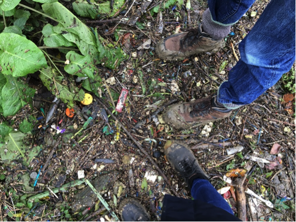
Figure 14 (left): High density of litter on the middle to upper terraces at Wandsworth Riverside Quarter, Winter/Spring 2018. Source: Environment Agency.

Figure 15 (right): Lower density of litter on the less vegetated middle to lower terraces at Wandsworth Riverside Quarter, Winter/Spring 2018. Source: Environment Agency.
4.3 Safety and Navigation
The structure does create a risk to navigation and human safety, due to:
- No lighting or marking has been installed
- boulders are outside of the fender line risking any mariner mistaking the fenders for moorings coming into contact with
- the height of the terraces allows a route for a person in the river
Signage on the piles would have been an additional enhancement to reduce risk.
5. Engineering
| Structural Element | Assessed Condition |
| Existing sheet steel pile wall + | Currently a breach in the steel sheet pile wall,
which has occurred since May 2017. Likely cause 4 factors in combination: missing tie rod with half tide weir removal (vibration and dredging) with a high spring tide with heavy rainfall. |
| Existing masonry/ concrete walls + | Unable to assess. |
| New concrete capping beam * | Unable to assess. |
| Timber terraces | Evidence of undermining of
terraces, possibly as a result of loss/ scour of the granular material, and exposure of the underlying geotextile. |
| Coir rolls/matting | These did not stabilise the re-profiled bank. |
| Rock rolls | Inshore of timber terrace appear to be in good condition |
| Rock armour toe | Appears reasonably stable, however the potential future risk of bed
lowering/ undermining failure with resultant loss of integrity of this element of the structure is unknown. |
* assumed due to lack of information of original data of installation.
+ assumed that this element was designed for inter-tidal environment with 50-year design life.
Table 3: Table showing individual engineering elements of Wandsworth Riverside Quarter and their expected lifespan.
Potential engineering improvements/ refinements
- Due to uncertainties and a lack of information on the original date of installation, it is difficult to predict the residual life of structural elements therefore presenting a risk in cutting down pre-existing structures for toe details for intertidal terraces.
- Design to consider potential habitat zones and take account of wave exposure as well as future climate change related issues, such as sea level rise of increased fluvial flow.
- Wave exposure and potential for reflected waves should be considered.
- Install rock rolls/gabions inshore of steel sheet toe piles, rear of steel sheet piles, and at corners between structures.
- Plant pre-grown intertidal habitat.
- Establish monitoring and maintenance regime for structures and intertidal habitat.
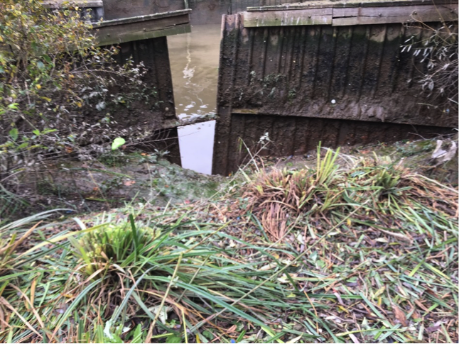
• Figure 16: Failed sheet steel pile wall to southern end of the Wandsworth Riverside Quarter site: As the front of the terrace this is the older structure which for much of the site was truncated to a lower height. Taken in winter/spring 2018. Source: Environment Agency.
6. Conclusions
6.1 Change to the feature in the 10 years since construction (2008 to 2018)
(This site was not included in the 2008 Estuary Edges document):
- The scheme has been considered a success in social and economic terms.
- Although this site is performing well for sediment accretion and plant diversity, poor fish and invertebrate diversity indicates that it is not performing well on all ecological aspects. This could be related to water quality at the mouth of the River Wandle but further information on fish and invertebrate diversity is definitely required to make conclusions.
- The site performs poorly for litter and safety and navigation.
- The good sediment accretion in this case study suggests that rock rolls behind the timber boards were probably unnecessary. Wave energy is low enough in this creek. Following High level design principle number 12: design for sustainability and adaptability would result in these rock rolls not being installed if this design were repeated again.
- The failing sheet steel pile points to two high level design principles:
- 11: Ensure retaining walls are engineered for the appropriate ground conditions, geology and land based loadings (e.g. soil, water, buildings, vehicles, etc.,) and
- Budget for monitoring and maintenance, including clearing of any collected litter.
- An improved monitoring regime (fixed point photography is just a start).