Case Studies
Royal Wharf, Western Embayment
Grid Reference TQ4087579704
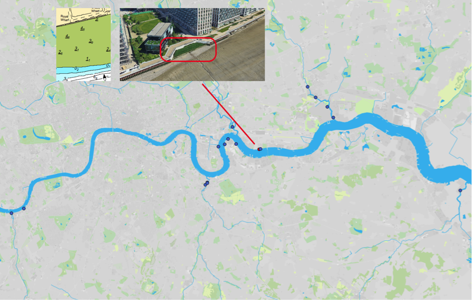
Figure 1: Map of Estuary edges sites pinpointing Royal Wharf, Western Embayment; inset graphics include Google Earth aerial photo of site and chart extract of Site (heights in metres relative to Chart Datum).
1. Introduction
1.1 Site Conditions Summary
| Salinity (during low fluvial flows) | ~7.5‰ (Wade, Hawes and Mulder, 2017) |
| Date of construction | 2014 |
| Tidal Range | 6.6m |
| Percentage of area accreted above design level | 60 % |
| Degree of exposure to waves: | High |
| Degree of exposure to currents: | Medium (straight section of estuary) |
| Max wave height | |
| Slope direction | South |
| Slope angle | Near horizontal normal and parallel to flow. |
| Average Whole Structure lifespan | 20-50 Years |
Table 1: Site conditions summary.
1.2 Site Characteristics
- Formerly known as Minocco wharf, this previously industrial site was redeveloped into high density housing and apartments in the 2010s and rebranded as Royal Wharf.
- Open estuary, currents are likely to be significant although the watercourse is fairly straight at this point running west-east.
- The fetch of around 600m for the prevailing south-south-westerly could generate some minor wind waves.
- This site is situated in a higher wash area for vessel and is likely to see waves of 1.2m. However, the river in this area is very wide with extensive foreshores in front of the enhancements which should help to dissipate the energy of the waves and likely not to see additional reflected wash.
- The area is used by commuter vessels and most inland commercial operations including tugs and tows.
1.3. What the developers did
- The original fronting sheet steel pile wall cut down to foreshore level.
- At the location where surface water outfalls were to be located, the developer used the headwall and apron to form the retaining wall of a 25m long terrace. The outfalls exit beneath the terrace just above foreshore level and therefore do not interact with it.
- These outfalls flowed from a swale cleverly integrated into the public open space.
- Sheet steel piles used to form the rear flood defence wall 5m further inland. The rear flood defence wall was capped and clad with a significant extent of concrete.
- Concrete with drainage holes was used to form a foundation for the terrace 0.6m beneath the fronting retaining wall and fill placed behind.
- Salix was employed to create a pre-planted design that would provide instant impact: this involved pre-planted coir rolls (with phragmites) interspersed with rock rolls to resist erosion from waves and currents in this exposed located.
- Similar to West India Dock phragmites beds, the terrace is at a high level and only inundated very occasionally.
2. Aerial photo and as-built drawings: plan view and cross-sectional view
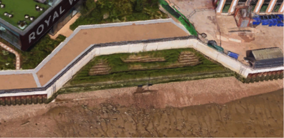
Figure 2: Aerial view of site (Google 3D image from 2018)
Artist’s impression combining ecology and engineering using a photograph not available.
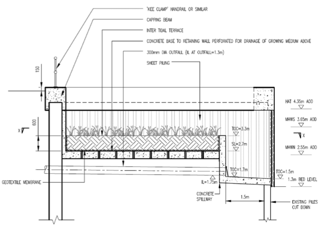
Figure 3: Section view from as built drawings
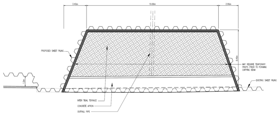
Figure 3: Plan view from as built drawings.
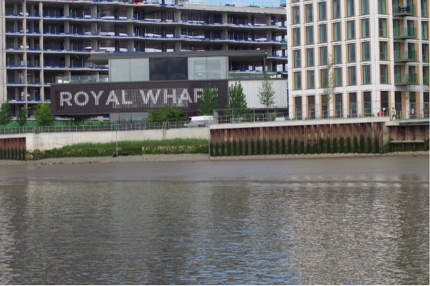
Figure 4: Photograph equivalent to a front view giving further information on the design. Source: Jacobs/TEAM2100.
3. Environmental
3.1 Inundation
During larger tides (spring) the terrace has water on it for over two hours and 22 minutes while smaller (neap) tides the terrace has water on it for 32 minutes.
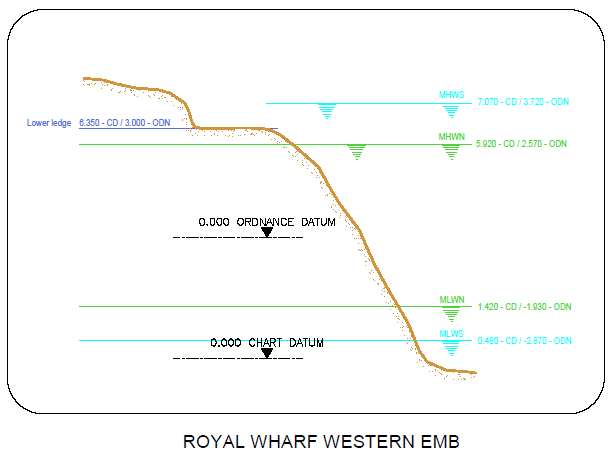
Figure 6: cross section of elevation of constructions (heights in CD)
3.2 Biodiversity
Adjacent Site:
Royal Wharf Eastern Terrace is immediately east of this site but has not had biodiversity sampling conducted. Greenwich peninsula terraces north east, at approximately 2 km further up estuary, is the nearest comparable site where sampling for biodiversity was conducted. It will be slightly less saline although is open estuary and will therefore be subject to the same fluid dynamics.
Fish:
Fish weren’t able to be measured at this site due the terrace being set very high in the tidal range and the water being 30cm lower than expected due to the prevailing winds. It was later estimated that even under normal conditions the terrace might not be inundated more often than 1 or 2 days per month and therefore not function well for fish. See Greenwich peninsula terraces north east for the nearest comparable location and likely species.
Botany:
Only common reed (Phragmites australis) and sea aster (Aster tripolium) were observed in this section. Despite the lack of diversity, the plants appeared to be thriving.
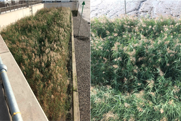
Figure 5: Royal Wharf. Common reed dominated higher level terrace.
Invertebrates:
The habitat type was Hediste diversicolor and Corophium volutator in littoral mud (Ls.LMu.UEst>Hed.CVol). The invertebrate assemblage present suggests that the succession of this habitat has progressed beyond the 6th tier (Figure 6) of 6 on the Joint Nature Conservation Committee classification system. This suggests that this site is performing really well.
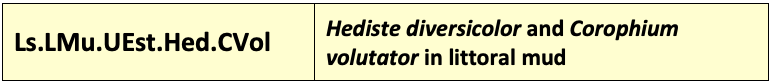
Figure 6: Joint Nature Conservation Committee classification system code for the habitat based on the invertebrate assemblage.
3.3 Geomorphology
60% of the accretable area has accreted with sediment above the design level (Figure 7).
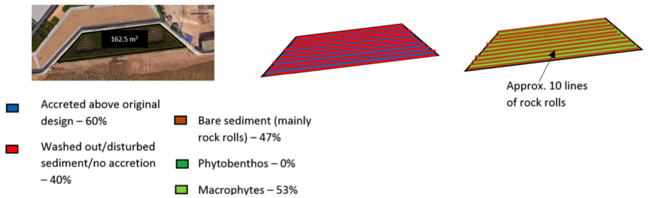
Figure 7: Schematic showing geomorphology and basic ecology.
Contributing reasons for this include:
- Although recessed back from currents, high vessel wake and minor wind waves result in the requirement for rock armour (‘rock rolls’) (Figure 8). Although these acrete to a small degree but, due to their nature of absorbing wave energy, the rock is still predominately exposed.
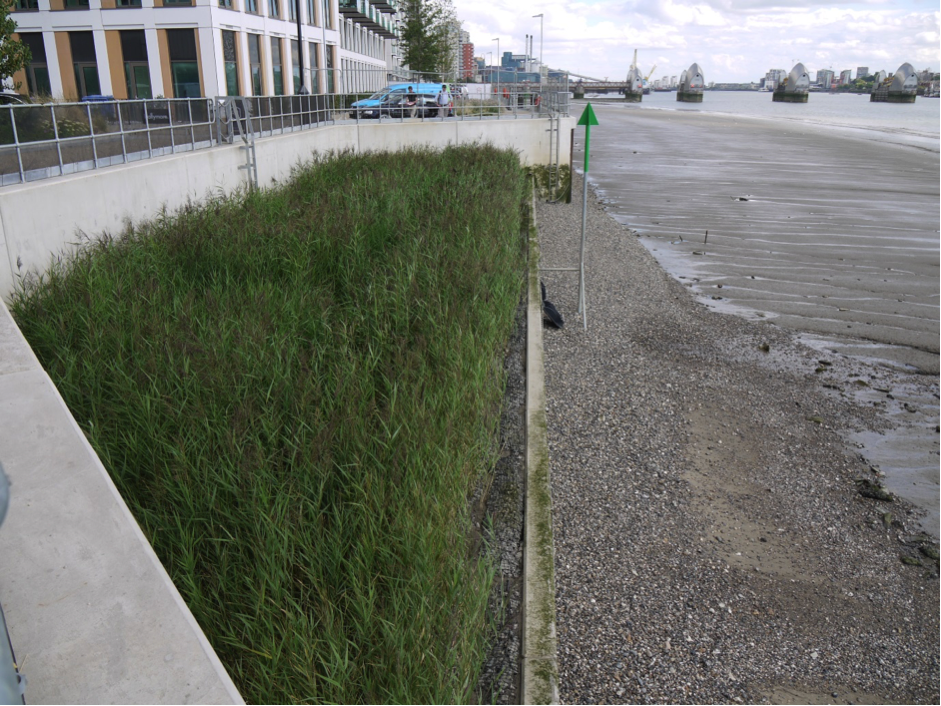
Figure 8: Royal Wharf Western Embayment: Luxuriant growth of phragmites which was pre planted in between lines of ‘rocks rolls’ (only visible at the front in this photo). Looking east in Winter 2018 (4 years since construction).
4. Social, Litter, Safety and Navigation
4.1 Social
The site was not publicly accessible at the time of the surveys and therefore no social surveys were completed as part of this review. It is recommended that these be completed once construction is complete.
4.2 Litter
Almost no litter was observed at Royal Wharf Western Embayment (Figure #9).
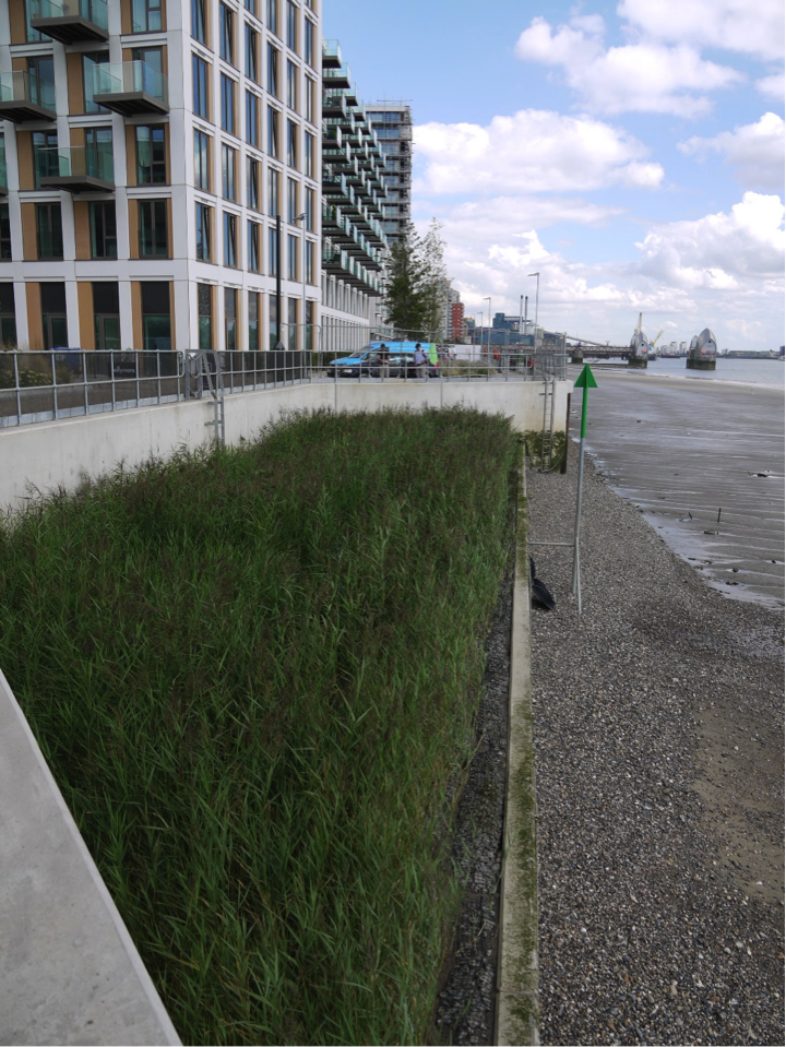
Figure 9: Absence of litter at Royal Wharf Western Embayment, Looking east in Winter 2018. Source: Environment Agency.
Contributing reasons for this include:
- Terrace very close to mean high water spring tide level meaning only inundated very occasionally.
- Likely high degree of maintenance as construction is still underway and homes are still for sale.
4.3 Safety and Navigation
The site is a considerable distance from the navigational channel across a shallow foreshore, and therefore protected by the lack of water depth in front of it. This means that the site is not a significant concern or navigational risk. Marking and lighting of the site is helpful and consideration of any change of use in the area.
5. Engineering
| Structural Element | Assessed Condition | Expected lifespan | Recommendations |
| Sheet steel pile flood defence wall and capping/cladding (rear) | Has a design life of 110 years. | > 50 years | N/A |
| Concrete retaining wall (front) and apron. | Has a design life of 110 years. | > 50 years | N/A |
| Concrete foundation to terrace and geotextile. | Has a design life of 110 years. | > 50 years | N/A |
| Existing sheet steel piles cut down to foreshore level* | Questionable as to whether this is integral to the design. | 20 to 50 years | Detailed inspection (including pile thickness measurement)
and comparison of existing foreshore level and prediction of future foreshore levels is recommended. |
| Rock rolls at front and rear of terrace | No comments. | 20 to 50 years | N/A |
*where it was not possible to assess the element, assumptions have been made that it was previously designed for inter-tidal environment with a 50-year design life but has since deteriorated.
Table 2:Table showing individual engineering elements of Royal Wharf Western Embayment and their expected lifespan.
Potential engineering improvements/ refinements
- Cutting down pre-existing structures to provide toe details presents a risk due to uncertainties/ lack of available information on original date of installation, design details and design assumptions (with respect to issues such as loading and assumed minimum foreshore levels). It is therefore difficult to predict residual life of these vital structural elements.
- Avoid vertical structures, in particular interfaces/ corners between vertical structures, which result in wave reflection and localised erosion.
- Design intertidal terraces to consider potential intertidal habitat zones, wave exposure (including vessel generated waves) and future climate change (sea level rise and increased fluvial flow).
- If necessary, replace softwood with recycled hardwood throughout to increase residual life.
- Establish a suitable monitoring and maintenance regime for the intertidal habitat/ structures/foreshore (monitor foreshore/ nearshore levels to identify any future potential risk of lowering which could result in undermining of the river wall at the toe).
6. Conclusions
6.1 Within the first 4 Years (2014 to 2018)
- The luxuriant vegetation growth and good invertebrate data shows that this terrace is performing well but this likely only for certain species. The south facing direction also is likely to help.
- Although there is no fish data, it is a good assumption that the sharp fronting edges will dissuade bottom dwelling fish such as flounder from accessing the site. The guidelines specific to intertidal vegetated terraces and for fish both stress this point. These edges are also very high, close to mean high water spring tide level, meaning that inundation is infrequent and short-lived.
- Rock armour and pre-planting is likely necessary for this high energy open estuary location and this advice is included in the geomorphology section.
- Avoiding vertical walls at that back and some of the sharp interfaces would reduce reflected wave energy further.
- The flora is very limited in its diversity due to the recent uniform pre-planting. Recommend variation in planting. This is included in the habitats and plants
- Better integration with the surface outfall which is below the terrace and could outfall onto the terrace providing variation in salinity and current speed.
- The site performs well for litter.
- The site performs well for safety and navigation.
- A monitoring regime is required.