Case Studies
Limo Peninsula
Grid Reference TQ3922681082
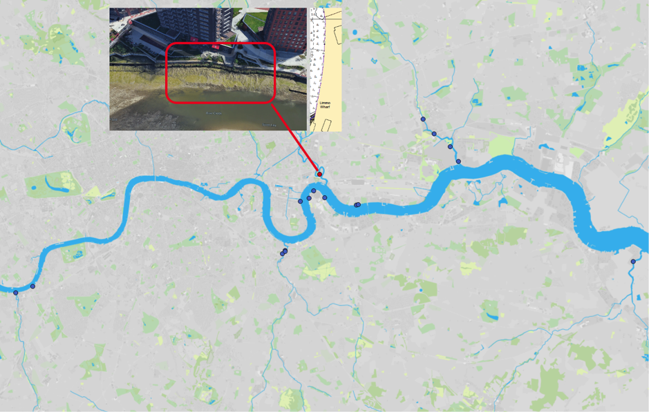
Figure 1: Map of Estuary edges sites pinpointing the Limo Peninusla; inset graphics include Google Earth aerial photo of site and chart extract of Site (heights in metres relative to Chart Datum).
1. Introduction
1.1 Site Conditions Summary
| Salinity (during low fluvial flows) | ~5.5‰ at mouth (open estuary) (Wade, Hawes and Mulder, 2017) |
| Date of construction | Early 2000s (exact date unknown) |
| Tidal Range | 6.6m |
| Percentage of area accreted above design level | 100 % |
| Degree of exposure to waves: | Low |
| Degree of exposure to currents: | Medium (including fluvial) |
| Max wave height | |
| Slope direction | West North West |
| Slope angle | Near horizontal normal and parallel to flow. |
| Average Whole Structure lifespan | 20-50 Years |
Table 1: Site conditions summary.
1.2 Site Characteristics
- Located approximately 1.5km upstream of the tidal mouth of the Tidal River Lee, known as Bow Creek, this site is sheltered from vessel wake although the prevailing south-south-westerly may cause some small wind waves.
- Although around 1/3rd of the River Lee flows through urban north and north east London, the middle and upper catchment is rural. It is therefore not as ‘flashy’ as some of the south London rivers which are predominately urban. However, fluvial currents are still likely to medium due to the size of this river.
- The salinity of 5.5‰ at the mouth will be slightly lower here due to the fluvial influence.
- It is neither on the outside on the inside of a meander but about halfway between the two situations.
1.3. What the developers did
- Previously an industrial site used for food manufacturing/packaging but now changed to modern residential tower blocks. Terraces constructed before the residential use was built.
- The following information is assumed from inspection:
- The existing wall appears to have been completed removed.
- Sheet steel piles were constructed as the backing flood defence and capped with timber. A significant section of mass concrete wall was installed immediately behind this and extending to a higher elevation.
- 5m riverward, hardwood timber piles were installed at approximately 2m intervals to form the fronting support to the terrace. Horizontal timbers (like groynes) were tied between the backing sheet steel pile wall and the fronting timber piles to give further stability and prevent grounding of vessels.
- Hardwood planks were placed between the timber ‘groynes’ to form the front of the terrace and backfilled.
- It is unknown if the terraces were pre-planted but similar terraces in Deptford Creek were allowed to colonise naturally.
2. Aerial photo and as-built drawings: plan view and cross-sectional view

Figure 2: Aerial view of site (Google 3D image from 2018)
Artist’s impression combining ecology and engineering using a photograph not available.
As built drawings not able to be located for this site.
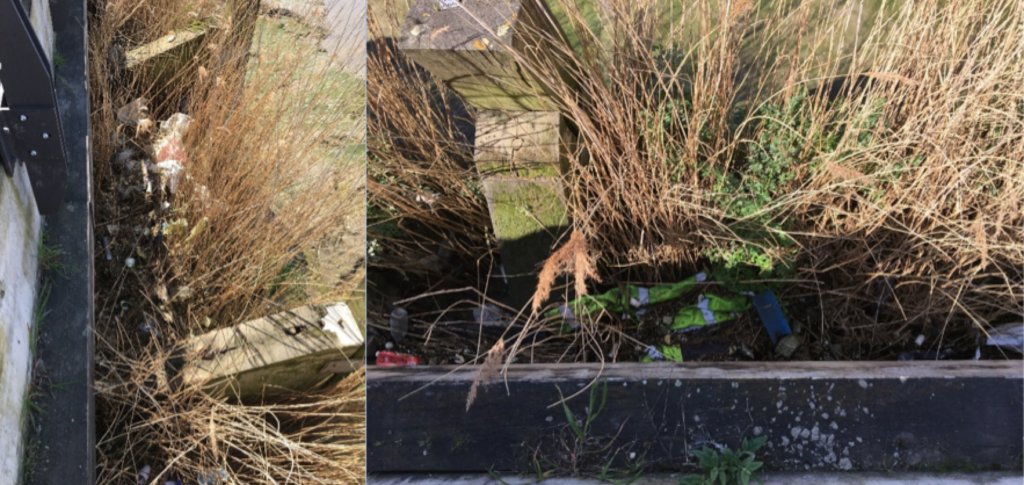
Figure 3 (left): Closest photograph to a section view drawing. Spring 2018. Source: Environment Agency; Figure 4 (right): Closest photograph to a plan view drawing. Spring 2018. Source: Environment Agency.
3. Environmental
3.1 Inundation
The immediate area of river in front of the terrace is a silt creek, with a low flow channel in the centre.
During larger tides (spring) the bed has water on it for over two hours 48minutes while during smaller (neap) tides the terrace has water on it for 14 minutes.
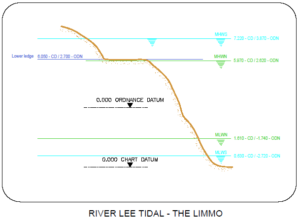
Figure 4: cross section of elevation of constructions (heights in CD)
3.2 Biodiversity
Adjacent Site/Comparable Site:
Although Greenwich Peninsula North East is directly opposite the mouth of the River Lee (Bow Creek), it is located in the open estuary and therefore there will be more saline and much more wave dominated. A more representative comparable site may be therefore be Deptford Creek Saxon Wharf due to its creek location and north west facing orientation.
Fish:
Fish weren’t measured at the site. See Deptford Creek Saxon Wharf for a comparable location.
Botany:
Flora weren’t measured at the site. See Deptford Creek Saxon Wharf for a comparable location.
Invertebrates:
Invertebrates weren’t measured at the site. See Deptford Creek Saxon Wharf for a comparable location.
3.3 Geomorphology
100% of the accretable area has accreted with sediment above the design level (Figure 5).

Figure 5: Schematic showing geomorphology and basic ecology.
Contributing reasons for this include:
- Sheltered from most wave energy.
- Excellent drainage through backfilled hardwood planks and no impermabable base of concrete (although unconfirmed).
- No timber capping on sheet steel piles maximising the backfilled areas.
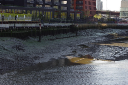
Figure 6: Limo peninsula terraces in the background showing excellent vegetation growth and adjacent unassessed terraces in the foreground with limited vegetation growth, showing the difference that good drainage and possibly a slight change in elevation can make to the vegetation that grows. Both are north west facing. Spring 2018 (~15 years since construction). Source: Jacobs/TEAM2100.

Figure 7: Similar photograph to Figure 6.
4. Social, Litter, Safety and Navigation
4.1 Social
The site is not easily publicly accessible and therefore no social surveys were completed as part of this review.
4.2 Litter
Litter found in high density throughout terrace: difficult to walk through terrace without stepping on litter.
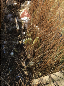
Figure 8: High density of the litter at the Limo peninsula terraces, Spring 2018. Source: Environment Agency.
4.3 Safety and Navigation
The site is set back and while not marked does not present a significant risk. There could be a benefit of some additional chains and lifesaving equipment.
5. Engineering
No official engineering assessment was conducted to this site. However, by comparing the adjacent terraces where sheet steel piles appear to be collapsing, fronting hardwood timber piles and planks may actually be a good design recommendation.
6. Conclusions
6.1 Within the first ~15 Years (Early 2000s to 2018)
NB: (This site was not included in the 2008 Estuary Edges document):
- Although no biodiversity surveys were conducted at this site, the luxuriant growth of vegetation suggests that the site is performing well. Tall tower blocks cutting out light from the east have done little to prevent its success. This is thought to predominately due to:
- The sheltered nature;
- The correct elevation of the terraces;
- Excellent drainage: a feature specific to the design of this terrace which incorporates lots of hard wood.
- The elevation and drainage is both stressed in the Guidelines specific to intertidal vegetated terraces.
- Although no fish data exists for this site, it does have a sharp vertical edge, common to terrace designs such as this. This will dissuade bottom dwelling fish such as flounder from accessing it. The guidelines specific to intertidal vegetated terraces and for fish both stress this point.
- Litter is the biggest problem at this site and could be reduced through of removal of some of the groynes from the design and the use of a boom. This has been stressed in the guidance on litter.
- No significant risk to safety and navigation but would benefit from chains and lifesaving equipment.