Case Studies
Greenwich Peninsula Terraces North West
Grid Reference TQ3898580302
This site was assessed for its cost-benefit and ecosystem services (amongst others) as case study CS—C3 in the coastal appendix (4) of the NERC funded ‘Greening the Grey: A Framework for Integrated Green Grey Infrastructure (IGGI)’ (Naylor et al., 2017)

Figure 1: Map of Estuary edges sites pinpointing Greenwich Peninsula Terraces North West; inset graphics include Google Earth aerial photo of site and chart extract of Site (heights in metres relative to Chart Datum).
1. Introduction
1.1 Site Conditions Summary
| Salinity (during low fluvial flows) | ~5 PPT (Wade, Hawes and Mulder, 2017) |
| Date of construction | 1997 |
| Tidal range | 6.6m |
| Percentage of area accreted above design level | 40 % |
| Degree of exposure to waves: | High |
| Degree of exposure to currents: | Medium (inside of meander bend) |
| Max wave height | 1.2 m |
| Slope direction | North West |
| Slope angle | Variable: Near horizontal to 1 in 7 normal to flow; Central terrace of 3: 1 in 65 parallel to flow |
| Average Whole Structure lifespan | 0-20 Years |
Table 1: Site conditions summary.
1.2 Site Characteristics
- Over 1300m of sheet piling (over this and Greenwich Peninsula North East) was in poor condition and needed to be replaced.
- Peninsula being redeveloped for high-density, high-value housing and facilities.
- This site is situated in a higher wash area likely to see waves of 1.2m. However, the river in this area is very wide with extensive foreshores infront of the features which should help to dissipate the energy of the waves and likely not to see additional reflected wash.
- The area is used by commuter vessels and most inland commercial operations including tugs and tows.
1.3. What the developers did
- The existing sheet pile wall was cut down to near beach level and capped with concrete.
- At 9.5m further inland a new sheet pile wall was installed.
- Terraces were created between the new wall and the foreshore using gabions, with surfaces near horizontal. Growing medium initially protected under coir matting.
- The site was planted with a variety of saltmarsh plants through coir matting. Substrate particle size distribution was a close match to foreshore for both stability in local area and habitat value.
2. Aerial photo and as-built drawings: plan view and cross-sectional view

Figure 2: Aerial view of site (Google 3D image from 2018)

Figure 3: Artist’s impression combining ecology and engineering using a photograph looking upstream at approx. low tide from Autumn 2003 (6 years since construction).

Figure 4: Looking upstream at low tide in Autumn 2017 from similar location as Figure 3 (approx. 20 years since construction).

Figure 5: Section view from as built drawings

Figure 6: Plan view from as built drawings. The location labelled 3 is the site and A is the cross section.
3. Environmental
3.1 Inundation
The immediate area of the river in front of the terrace dries during low tides and a large area of silt is exposed in front of the terrace around a no anchoring area. The foreshore is made from a muddy and silty substrate (See chart extract Figure 1). During larger tides (spring), the terrace has water on it for four hours and forty-eight minutes. During smaller (neap) tides, the terrace has water on it for three hours and fifty-one minutes, while the top of the terrace is always dry in all tides.
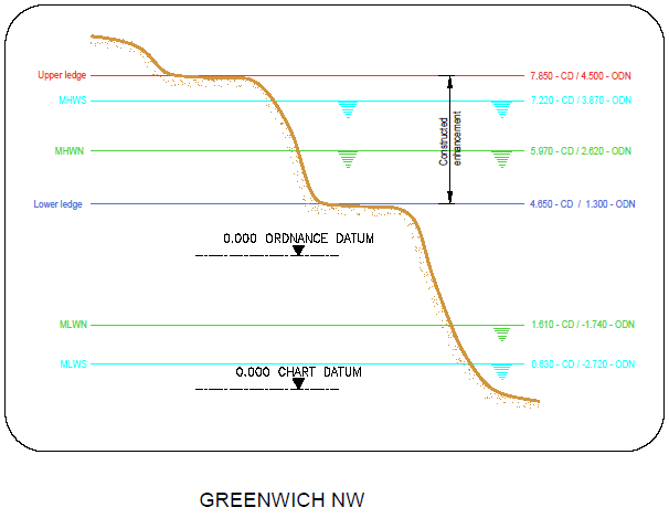
Figure 7: cross section of elevation of constructions (heights in CD)
3.2 Biodiversity
Adjacent Site:
This site is part of a reedbed system along the East length of Greenwich Peninsula built either side of the infrastructure needed for the passenger ferry. The adjacent site Greenwich Peninsula North East Terrace lies downstream of this site and is comparable in situation, water chemistry and size. Therefore the ecology and geomorphology should be very similar.
Fish:
Fish weren’t measured at the site. See Greenwich Peninsula North East Case Study.
Botany:
Flora weren’t measured at the site. See Greenwich Peninsula North East Case Study.
Invertebrates:
Invertebrates weren’t measured at the site. See Greenwich Peninsula North East Case Study.
3.3 Geomorphology
Only 40% of the accretable area has accreted with sediment above design level (Figure 8). The entire lower terrace and parts of the central terrace have eroded out (Figures 3, 4 and 11). The rear level of the central terrace has eroded downwards reducing any available connectivity with the landward most terrace (Figures 9 and 10) for bottom dwelling fish which do not like moving up and over submerged edges.

Figure 8: Schematic showing geomorphology and basic ecology.
Contributing reasons for this include:
- Waves:
- Wave energy is high (Table 1).
- Although there is limited fetch, vessels travelling on the right of the channel generate wave wash up alongside the upstream facing wall washing out fill at the front of the terrace and depositing it at the back (Figure 9).

Figure 9: Looking downstream at low tide in Summer 1999 (2 years after construction).

Figure 10: Greenwich Peninsula North West: Looking downstream at mid tide in Summer 2017 (circa. 20 years since construction).

Figure 11: Greenwich Peninsula North West: Looking downstream at low tide in Autumn 2017 (approx. 20 years since implementation).
4. Social, Litter, Safety and Navigation
4.1 Social
Questionnaires were completed adjacent to the estuary edge sites that had public access. The questions sought to understand how the Thames and intertidal green spaces were viewed and understood. These questions tell us about different value sets that can be measured. Figure 12 shows us that residents and passers’ by at Greenwich Peninsula North East (samples size:22 people; 3:1 male:female ratio; aged between 15-75 years old) were on average neutral about the terraces and more negative about the Thames in general.

Figure 12: Pie charts showing distribution of positive, negative and neutral comments from passer’s by regarding varying aspects of the estuary edge feature.
As part of the questionnaire, we asked them what the first word that came in to their head was when thinking of the Thames at the beginning of the interview and again at the end after they’d answered all the questions (see Figure 13). This showed a positive perception shift from neutral or negative to positive. This indicated that education and interpretation of the site would increase people’s connection to the terrace and the river.

Figure 13: First (left) and last (right) words of what respondents think of the river asked at the beginning and end of a questionnaire.
4.2 Litter
Litter was found in corners and multiple but discrete areas across terrace (Figure 14).

Figure 14: Litter to rear of downstream end of terrace on top of washed out fill, Autumn 2017.
4.3 Safety and Navigation
This site has some challenges for safety and navigation:
- Potential risk of vessels mistaking it as a safe haven due to lack of markings and interpretation.
- Access and egress from the site is not encouraged by design of high fences on land side.
- The height of the lower terrace relative to the lower foreshore level is around 1m in places making it challenging for anyone trying to rescue themselves.
- The absence of grab chains around the structure and adjacent walls means that there are limited areas of exit for a person in the water around this site.
5. Engineering
| Structural Element | Assessed Condition | Expected lifespan | Recommendations |
| Sheet Pile Wall | Unable to assess | Assumed residual life <20 years | detailed inspection and comparison of existing foreshore level and prediction of future foreshore levels |
| Gabion toe | Evidence of failure in places | <20 Years | |
| Gabion Terrace | Good | 20-50 Years | |
| Set-back sheet pile wall* | Good | 20-50 Years |
* assumed that this element was designed for inter-tidal environment with 50-year design life.
Table 2: Table showing individual engineering elements of Greenwich Peninsula North West Terraces and their expected lifespan.
Potential engineering improvements/ refinements
- Cutting down pre-existing structures to provide toe details presents a risk due to uncertainties/ lack of available information on original date of installation, design details and design assumptions (with respect to issues such as loading and assumed minimum foreshore levels). It is therefore difficult to predict residual life of these vital structural elements.
- Avoid the use of vertical structures, in particular interfaces/ corners between vertical structures, which result in wave reflection and localised erosion.
- Designs to consider potential habitat zones and to take account of wave exposure and future climate change (sea level rise and increased fluvial flow).
- Install rock rolls/ gabions: i) immediately inshore of steel sheet toe piles; ii) riverward of rear steel sheet piles and iii) at interfaces/ corners between vertical structures to reduce scour due to wave reflection off vertical structures.
- Install pre-grown intertidal habitat planting (which is tolerant to wave action) with suitable substrate.
- Establish a suitable monitoring and maintenance regime for the intertidal habitat/ structures/ foreshore (monitor foreshore/ nearshore levels to identify any future potential risk of lowering which could result in undermining of the river wall at the toe).
6. Conclusions
6.1 Change to feature in the 10 years since construction (1997 to 2007):
- Wave action led to lifting of the matting and extraction of many young plants, necessitating some replanting, though there was also considerable natural colonisation.
- Re-planting directly into the substrate without erosion matting was most successful with Common Reed, Grey Club-rush Sea Club-rush and Sea Aster, several species surviving well below or above the main ‘saltmarsh zone’.
- Failure to install rhizome breaks has led to excessive dominance by Common Reed.
- Extensive monitoring at both Greenwich Peninsula North West and North East has shown intense use of the terraces by Sea Bass and other species and the ‘folding’ design has enabled use by Flounder and adult Common Goby access to the terraces.
- At the time this site was considered to be a highly successful, benchmark design, though a few gabions appeared to be breaking down.
6.2 Change in the feature in the last 10 years (2007 to 2017):
- See Conclusions in Greenwich Peninsula North East where biodiversity was measured.
- An apparent increase in energy (wave/wash/current) has caused significant erosion. Use of groynes to reduce currents/movement of gravel, rock rolls to resist scour by waves and avoiding use of walls (to reduce wave reflection) could help.
- The upper terrace and parts of the central terrace still perform well.
- Blue geotextile revealed by erosion leads to design principle to avoid geotextile in all future designs.
- Collapse of gabions and concern of wire breaking free leads to design principle to avoid use of gabions in future designs. Hard wood to form terraces (as used in Greenwich Peninsula North East and Deptford Creek,Thanet Wharf) would be better as a retaining wall.
- The site performs well in terms of litter collection but could benefit from multiple improvements for safety and navigation.
- The site was noticed by passersby but to a lesser degree than upstream in more urbanised areas where the channel is narrower. Interpretation boards and education would help to boost their social value and passersby understanding of their role in river ecology.