Case Studies
Greenwich Peninsula Terraces North East
Grid Reference TQ3950679965
This site was assessed for its cost-benefit and ecosystem services (amongst others) as case study CS—C3 in the coastal appendix (4) of the NERC funded ‘Greening the Grey: A Framework for Integrated Green Grey Infrastructure (IGGI)’ (Naylor et al., 2017)

Figure 1: Map of Estuary edges sites pinpointing Greenwich Peninsula Terraces North East; inset graphics include Google Earth aerial photo of site and chart extract of Site (heights in metres relative to Chart Datum).
1. Introduction
1.1 Site Conditions Summary
| Salinity (during low fluvial flows) | ~5.5‰ (Wade, Hawes and Mulder, 2017) |
| Date of construction | 1997 |
| Tidal Range | 7m |
| Percentage of area accreted above design level | 75 % for eastern section, 65% of central section, 95% for western section. |
| Degree of exposure to waves: | High |
| Degree of exposure to currents: | High |
| Max wave height | 1.2m |
| Slope direction | East-North-East |
| Slope angle | 1 in 9 normal to flow, near horizontal parallel to flow for western and central sections but 1 in 17 parallel to flow for eastern most sections. |
| Average Whole Structure lifespan | < 20 years |
Table 1: Site conditions summary
1.2 Site Characteristics.
- Prior the redevelopment of the peninsula in the late 1990s, over 1300m of sheet piling (over this and Greenwich Peninsula Terraces North West) was in poor condition and needed to be replaced.
- The site was redeveloped for the Millennium exhibition and high-density, high-value housing and facilities.
- This site is situated in a higher wash area likely to see waves of 1.2m. However, the river in this area is very wide with extensive foreshores in front of the enhancements which should help to dissipate the energy of the waves and likely not to see additional reflected wash.
- The area is used by commuter vessels and most inland commercial operations including tugs and tows.
1.3. What the developers did
- A new L-shaped concrete wall was installed approximately 7m inland of the existing sheet pile wall and capped with concrete.
- For the eastern section (Figure 2a), a frontage of approx. 300m, the existing sheet pile wall was cut down at or just above beach level providing gentle slopes parallel to the river flow of around 1 in 17 allowing access for bottom dwelling fish. The truncated piles were capped with timber. For most of the central section and all of the western section, the sheet piles were truncated to a higher level, had a concrete wall inserted immediately behind them to ensure stability and capped with timber.
- For the eastern and a fewer easterly parts of the central section (Figure 2b and c), intermediate terraces were created between the new wall and the foreshore using gabions for the lower terraces and wooden piles for the higher ones.
- All surfaces normal to the river flow had a slope of around 1 in 9.
- Growing medium initially protected under coir matting.
- Pre-planting was conducted with a variety of saltmarsh plants placed through coir matting.
- Substrate particle size distribution was a close match to foreshore for both stability in local area and habitat value.
2. Aerial photo and as-built drawings: plan view and cross-sectional view
This site is so long in extent, it has to be split into 3 sections to study it: eastern-most, central and western-most. The central and western-most sections are immediately either side of the passenger ferry dock.
(a)

(b)

(c)

Figure 2: Aerial view of site (Google 3D image from 2018) (a) Eastern-most, (b) Central and (c) Western-most sections.

Figure 3: Artist’s impression combining ecology and engineering for the western-most section (which did not include intermediate terraces) using a photograph from Autumn 2003 (6 years after construction).

Figure 4: Section view from as built drawings for the central and western-most sections which did not include intermediate terraces.
(a)(b)
(c)

Figure 5: Photographs showing the typical construction of the eastern-most section of the terrace (in the absence of plans) which included lower truncation of the original sheet steel piles and intermediate terraces formed with gabions for the lower ones and timber piles for the higher ones (a) equivalent to plan view (Source: Environment Agency, (b) equivalent to section view of upper terraces (Source: Environment Agency and (c) equivalent to section view of lower terraces (Source: Mark Spencer).

Figure 6: Plan view from as built drawings. The location labelled 2 is the site and B is the formal cross section (Figure 4).
3. Environmental
3.1 Inundation (figure 7)
The immediate area of river in front of the terrace dries during low tides and is predominantly silty foreshore with some gravel.
During larger tides (spring) the terrace has water on it for over three hours 20 minutes while the top of the terrace is covered for one hour and 17 minutes. During smaller (neap) tides the terrace has water on it for one hour and 19 minutes and the top of the terrace is only reached for 3 minutes.


Figure 7: cross section of elevation of constructions (heights in CD)
3.2 Biodiversity
Adjacent Site:
This site is part of a reedbed system along the Eastern length of Greenwich Peninsula built either side of the infrastructure needed for the passenger ferry. The adjacent site Greenwich Peninsula North West Terrace lies upstream of this site and is comparable in situation and water chemistry although smaller in length. Therefore the ecology and geomorphology should be very similar.
Fish:
Species found on this site incorporated both freshwater and marine fishes including Bass (Dicentrarchus labrax ); Common Goby (Pomatoschistus microps ); Thin Lipped Grey Mullet (Liza ramada ); Flounder (Platichthys flesus ); Eel (Anguilla anguilla ); Sand-smelt (Atherina presbyter ); Sand Goby (Pomatoschistus minutus ). This site is one of the best researched with several reports between 1998 – 2006 showing how fish use intertidal sites in urban estuaries. One notable feature on the downstream terraces surveyed in this study is the formation of drainage channels across the site. Although offering a very truncated horizontal profile, parts of the terraces are beginning to develop true saltmarsh characteristics. Since fish access and leave marshes via these channels, this can only benefit fish utilisation.
Botany:
The Sea Club-rush (Bolboschoenus maritimus), Grey Club-rush (Schoenoplectus sp.), Sea Aster (Aster tripolium ssp. tripolism var tripolium), Hemlock Water-Dropwort (Oenanthe crocata) and the Common Reed (Phragmites austalis) were all planted on the original site and documented in 2003. Although some photography has been taken to assess difference in growth, ongoing fixed-point photography would allow for better understanding of the changes on site. The photography available has shown that some vegetation may be retreating. Some of the common reeds has also lost growth heights in documentation from 2016-2017. Common reed and sea aster appear to be the most successful, while Sea Club-rush appears to be diminishing. This is surprising given Sea Club-rush’s ability to withstand brackish waters. English scurvygrass (Cochlearia anglica), was locally frequent amongst the sea aster in the southern section of the survey area. This species is a known halophyte (salt-tolerant/demanding plant) and its presence here and at other locations would appear to support the hypothesis that this section of the Thames is becoming more saline. For details of all species recorded, please see the botany report 2017. Links in the Further Reading section.

Figure 8: Greenwich Peninsula foreshore at the Millennium Site. Ecological terraces were incorporated into the replacement of an old flood defence wall. The terraces provide important intertidal estuarine habitats for a diversity of estuarine plants and wildlife [image and text derived from Millennium Vegetation Report 2003].
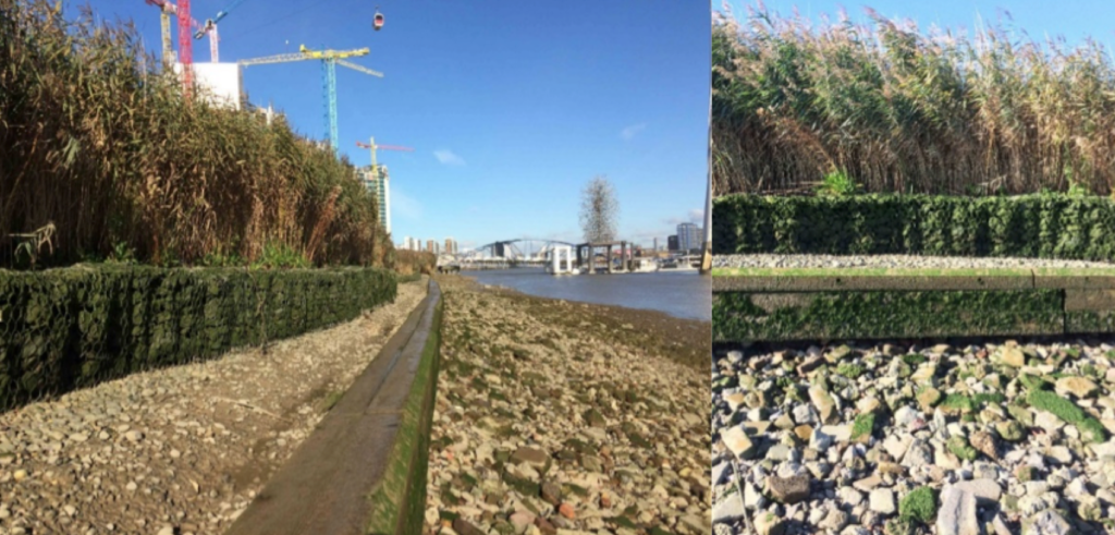
Figure 9: Greenwich Peninsula Millennium Terraces. Upper terrace dominated by common reed (Phragmites australis). Compared to fig. 1, the middle terrace appears to be largely devoid of vegetation. Image taken approximately 50 metres north of fig. 12.

Figure 10: Greenwich Peninsula Millennium Terraces. Left to right: Upper terrace dominated by common reed in northern section of the scheme; Probably planted sea aster (Aster tripolium) in fruit; sea aster growing on the margins of narrow gully created by retreating tide and currents.
| Planted | Natural Colonised | Dominant | Notable species |
| Sea Club-Rush (Bolboschoenus maritimus) | Sea Aster (Aster tripolium ssp. tripolium var tripolium) | English Scurvygrass (Cochlearia anglica) | |
| Common Reed (Phragmites australis) | English Scurvygrass (Cochlearia anglica) | ||
| Grey Club Rush (Schoenoplectus sp.) |
Table 2: Showing the planted, assumed naturally colonised, dominant and notable species found at the site. For all species recorded, please see the botany report, 2017.
Invertebrates:
The habitat soil type is Littoral sediment (LS.). The invertebrate assemblage present suggests that the succession of this habitat has not progressed beyond the 2nd tier (Figure 11) of 6 possible on the Joint Nature Conservation Committee classification system. This suggests that this habitat is not performing well.

Figure 11: Joint Nature Conservation Committee classification system code for the habitat based on the invertebrate assemblage.
3.3 Geomorphology
The eastern and central sections are so large that a sample had to be mapped in order to create the required geomorphology schematics (Figure 12). Of the eastern-most section (Figure 12a), 75% of the sample site accreted with sediment above the design level (Figure 12). Of the central section (Figure 12b), a slightly smaller 65% of the sample site accreted with sediment above the design level. Of the western-most section (Figure 12c), a much larger 95% of the surface area accreted with sediment above the design level.
(a)

(b)

(c)

Figure 12: Schematic showing geomorphology and basic ecology of a studied subsection of the eastern-most end of the site.
- Shallow slope angles.
- Sheltered from the prevailing south-south-westerly winds and thus wind waves.
- Sheltered from currents on the inside of the meander bend.
- Vessel wake likely to be causing the lack of sediment accretion that is seen:
- Walls in the opposing direction to vessel travel suffer from vessel wake and scour which erodes and deposits the fill at the rear of the terrace (Figure 13).
- Erosion of gulleys into the lower terraces and up into the higher terraces was found specifically between the eastern and central sections where the fronting piles are still at or close to beach level but there is increasing proximity to the passenger ferry dock: higher piles or groynes may be necessary to shelter from vessel wake and achieve good sediment accretion rates.
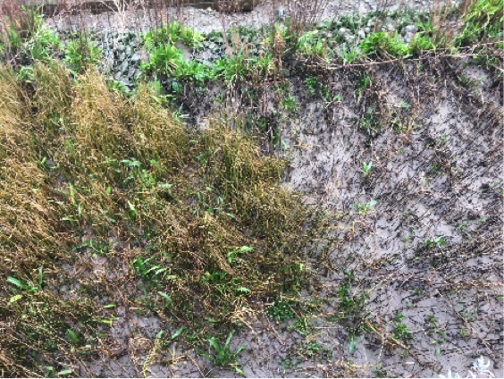
Figure 13: Good sediment accretion at eastern end of terrace, Autumn 2017 (20 years since construction). Source: Environment Agency.
(a)(b)

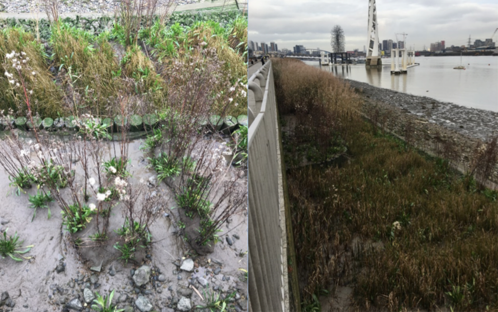
Figure 13: Fill deposited at the rear of the terrace which has been eroded out by vessel wake. This is a problem where walls oppose the direction of vessel movement. Autumn 2017 (20 years since construction). (a) Looking up-river from the far eastern end of the site. Source: Environment Agency and (b) Immediately up river of the passenger ferry pontoon Source: Jacobs/TEAM2100.
(a)(b)

Figure 14: Signs of erosion on the central section, 20 years since construction: (a) Gulley cutting back into an intermediate terrace, Winter 2017. Source: Mark Spencer and (b) Less of sediment forming islands of vegetation on the upper terrace, Autumn 2017. This could be linked to the energy from vessel wake.
4. Social, Litter, Safety and Navigation
4.1 Social
Questionnaires were completed adjacent to the estuary edge sites that had public access. The questions sought to understand how the Thames and intertidal green spaces were viewed and understood. These questions tell us about different value sets that can be measured. Figure 14 shows us that residents and passers’ by at Greenwich Peninsula North East (samples size:22 people; 3:1 male:female ratio; aged between 15-75 years old) were on average neutral about the terraces and more negative about the Thames in general.

Figure 14: Pie charts showing distribution of positive, negative and neutral comments from passer’s by regarding varying aspects of the estuary edge enhancement.
As part of the questionnaire, we asked them what the first word that came in to their head was when thinking of the Thames at the beginning of the interview and again at the end after they’d answered all the questions (see Figure 15). This showed a positive perception shift from neutral or negative to positive. This indicated that education and interpretation of the site would increase people’s connection to the terrace and the river.

Figure 15: First (left) and last (right) words of what respondents think of the river asked at the beginning and end of a questionnaire.
4.2 Litter
Litter was found in corners and multiple but discrete areas across the site (Figure 16). It was possible to walk across the site without stepping on litter.

Figure 16: Litter from the upper terraces at the central section of the site, Autumn 2017.
Other contributing reasons for this are thought to be:
- Sheltered from the prevailing south-south-westerly wind and therefore wind generated waves.
- Vessel wake still causing some wash-in of litter.
- Extensive fragamites good at trapping litter and little maintenance performed.
4.3 Safety and Navigation
Construction on the site was done during a time of significant change of use. This has meant that while the whole area changed there may have been different requirements had the terraces been constructed separately to the wider river works. These would be linked to the following risks to safety and navigation:
- Potential risk of vessels mistaking it as a safe haven due to lack of markings and interpretation.
- Access and egress from the site is not encouraged by design of high fences on land side.
- The height of the lower terrace relative to the lower foreshore level is around 1m in places making it challenging for anyone trying to rescue themselves.
- The absence of grab chains around the structure and adjacent walls means that there are limited areas of exit for a person in the water around this site.
5. Engineering
| Structural Element | Assessed Condition | Expected lifespan | Recommendations |
| Existing concrete river wall/sheet steel pile wall cut down to beach level and capped. + | Not inspected. | < 20 | Detailed inspection (including pile thickness measurement) and comparison of
existing foreshore level and prediction of future foreshore levels. |
| Terrace infill. | Loss against walls in the opposing direction to vessel movement and on the eastern/central boundary. | N/A (structural integrity not based on fill) | |
| Gabions/wooden piles * | Not inspected. | 20 – 50 | |
| Concrete L-wall * | Not inspected. | 20 – 50 |
+Conservation assumption as this structure was not new when constructed.
*Standard assumption that the element was designed for the inter-tidal environment with a 50 year design life and has since deteriorated.
Table 3:Table showing individual engineering elements of Greenwich Peninsula Terraces North East and their expected lifespan.
Potential engineering improvements/ refinements
- Cutting down pre-existing structures to provide toe details presents a risk due to uncertainties/ lack of available information on original date of installation, design details and design assumptions (with respect to issues such as loading and assumed minimum foreshore levels). It is therefore difficult to predict residual life of these vital structural elements.
- Avoid the use of vertical structures, in particular interfaces/ corners between vertical structures, which result in wave reflection and localised erosion.
- Install rock rolls/ gabions: i) immediately inshore of steel sheet toe piles; ii) riverward of rear steel sheet piles and iii) at interfaces/ corners between vertical structures to reduce scour due to wave reflection off vertical structures.
- Establish a suitable monitoring and maintenance regime for the intertidal habitat/ structures/foreshore (monitor foreshore/ nearshore levels to identify any future potential risk of lowering which could result in undermining of the river wall at the toe).
6. Conclusions
6.1 Within the First 11 Years (1997 to 2008):
- Wave action led to lifting of the matting and extraction of many young plants, necessitating some replanting, though there was also considerable natural colonisation.
- Re-planting directly into the substrate without erosion matting was most successful with Common Reed, Grey Club-rush Sea Club-rush and Sea Aster, several species surviving well below or above the main ‘saltmarsh zone’.
- Failure to install rhizome breaks has led to excessive dominance by Common Reed.
- Extensive monitoring at both Greenwich Peninsula North West and North East has shown intense use of the terraces by Bass and other species and the lack of edge and gentle shore parallel slopes has enabled use by Flounder and adult Common Goby.
- At the time this site was considered to be a highly successful, benchmark design.
6.2 Within the Next 10 Years (2008 to 2019):
- An increase in erosion close to the passenger ferry dock suggests an increase in vessel wake. Use of groynes and/or higher sheet steel piles may be necessary to achieve good sediment accretion rates close to vessel docks. Where walls are constructed opposing the direction of vessel movement, more rip rap/scour protection should be placed. This information has been placed into the geomorphology section.
- Those terraces further away from the passenger docks still perform well.
- The greater density and variety of species was believed to be associated with the significant development of vegetation cover on the terraces since 1998
- Although plant and fish data suggest that this site is performing well, the invertebrate assemblage suggests otherwise: this could be linked to the erosion.
- The presence of English scurvygrass suggests that this section of the Thames is getting more saline.
- Litter is a problem but not extensively so. Booms or higher fronting piles could help reduce litter (as well reduce erosion) provided there are adequate access gaps for fish.
- The site could benefit from multiple improvements for safety and navigation.
- The site would benefit from interpretation to better connect passer-by to the terraces and river.
- A monitoring regime is required.