Case Studies
Deptford Creek Vertical Wall Renewal
Grid Reference TQ3763877392
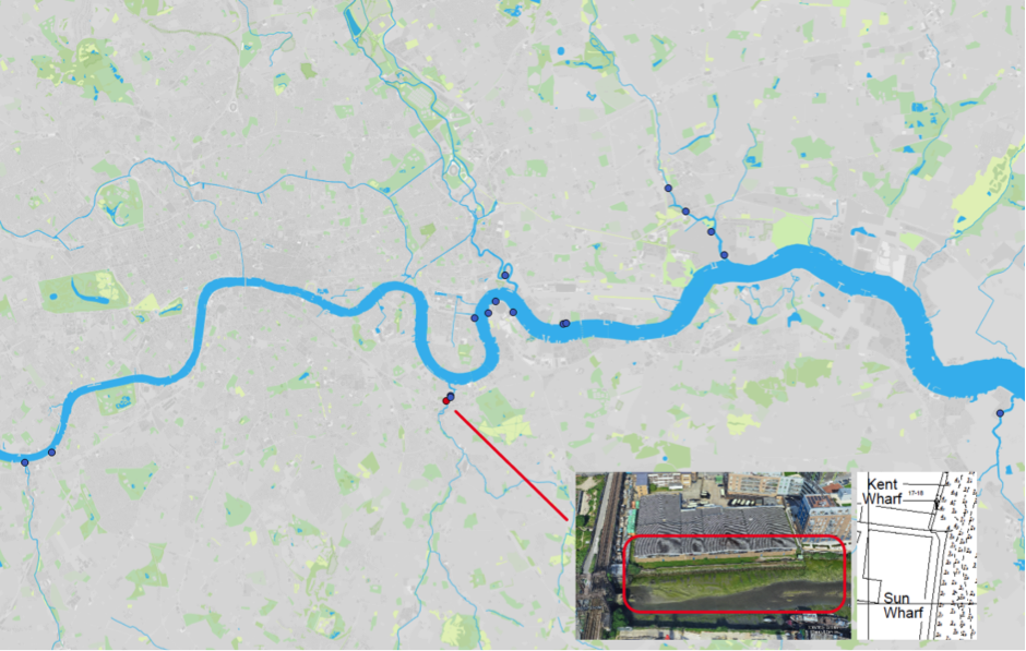
Figure 1: Map of Estuary edges sites pinpointing Deptford Creek Vertical Wall Renewal; inset graphics include Google Earth aerial photo of site and chart extract of Site (heights in metres relative to Chart Datum).
1. Introduction
1.1 Site Conditions Summary
| Salinity (during low fluvial flows) | At creekmouth ~4.8‰ (Wade, Hawes and Mulder, 2017) |
| Date of construction | 1997 |
| Tidal Range | 6.7m |
| Percentage of area accreted above design level | 67 % |
| Degree of exposure to waves: | Low |
| Degree of exposure to currents: | Medium (fluvuial currents) |
| Max wave height | |
| Slope direction | East |
| Slope angle | Horizontal |
| Average Whole Structure lifespan | 20-50 Years |
Table 1: Site conditions summary.
1.2 Site Characteristics
- Located approximately 700m upstream of the tidal mouth of the River Ravensbourne, this site is sheltered from wave energy.
- The River Ravensbourne flows predominantly through urban south east London, but the headwaters are rural. It is therefore ‘flashy’ in its discharge and fluvial currents are at least medium.
- Salinity is semi-maritime at an average of around 2‰.
- Old creek walls of wooden construction had deteriorated to such an extent that in many places only plant roots were holding the wall in place.
1.3 What the developers did
- A wall option was opted for with a terrestrial (above high water on spring tides) terrace on the top.
- New sheet steel pile walls were installed and clad with wooden panelling, with a variable void created between the panels and the sheet steel piles. This gap was filled with gravel/sand substrate to act like a ‘vertical beach’.
- A 15 to 20m length of the terrestrial terrace included a compacted sand ‘cliff’ designed to allow Kingfishers and insects such as bees to create burrows.
- 60m further south (up the creek) brick walls in good condition were clad at 2 levels with horizontal wooden planters filled with rubble (Figure 3c).
- Pre-planting was not conducted.
2. Aerial photo and as-built drawings: plan view and cross-sectional view
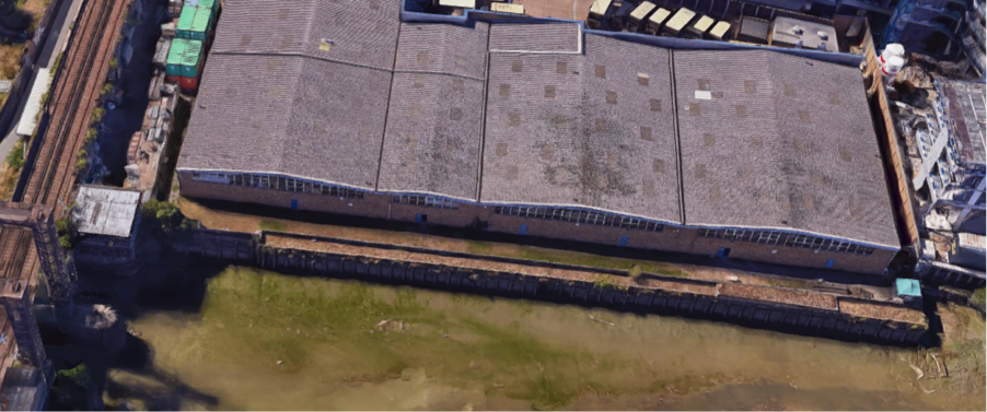
Figure 2: Aerial view of site (Google 3D image from 2018)
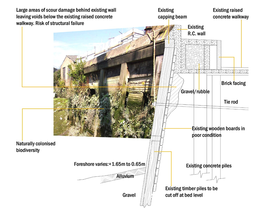
Figure 3a: Before: Artist’s impression combining ecology and engineering using a photograph from before the 1997 Deptford Creek Vertical Wall Renewal.
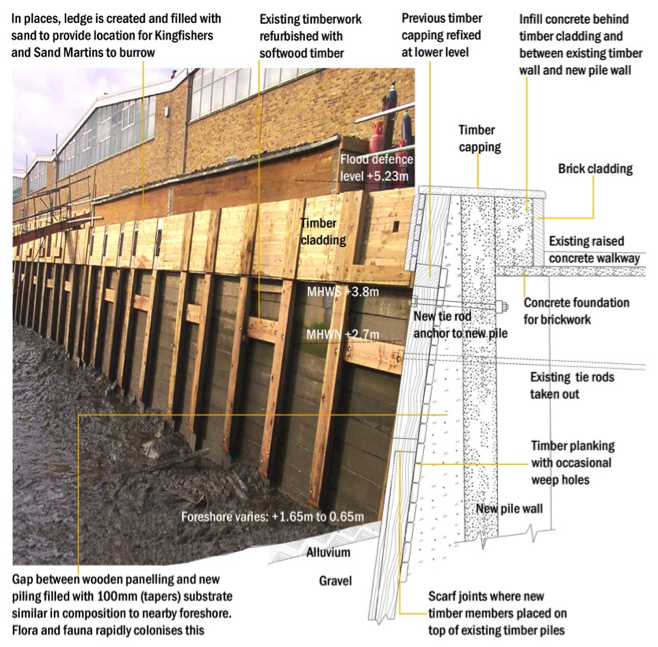
Figure 3b: After: Artist’s impression combining ecology and engineering using a photograph from after the 1997 Deptford Creek Vertical Wall Renewal.
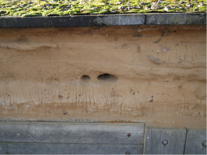
Figure 3c: After: Close up of sand cliff in Deptford Creek Vertical Renewal taken in Winter 2017/18 showing some burrowing activity.
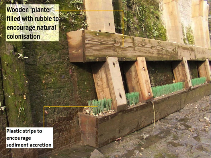
Figure 3d: After: 60m further south (up the creek) brick walls in good condition clad at 2 levels with horizontal wooden planters filled with rubble.
3. Environmental
3.1 Inundation
The immediate area of river in front of the terrace is a silty canalised creek, with a small low flow channel in the centre.
The top of the wall is dry. During larger tides (spring) the terrace has water on it for two hours 48minutes. During smaller (neap) tides the terrace is only reached for 14 minutes
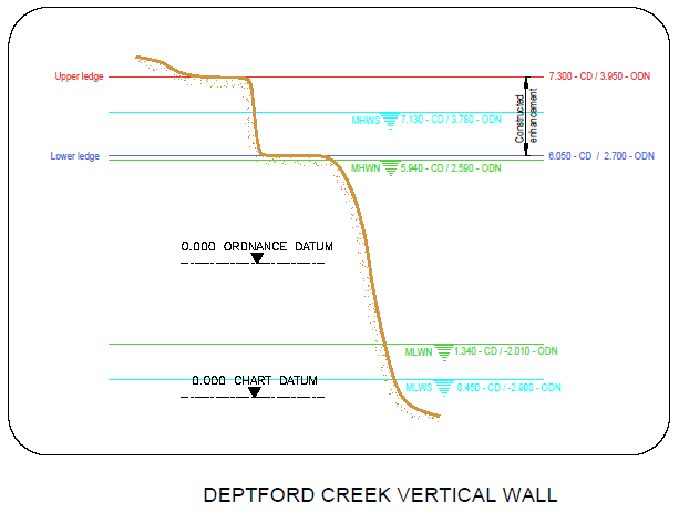
Figure 4: cross section of elevation of constructions (heights in CD)
3.2 Biodiversity
Adjacent Site:
This site is a few hundred metres south of Deptford Creek Saxon Wharf which is a similar location but includes intertidal terraces. The fluid dynamics and water chemistry should be equally comparable.
Fish:
The design of the estuary edge feature at this site does not include any continuous sloping or horizontal surface therefore a fyke net could not be deployed and there was no method to capture fish. Attempts were made to assess fish movements up the timber wall treatments visually from the EA vessel provided, but poor visibility prevented this. Proving that small fish do associate with vertical structure in a tidal environment is very difficult. Visual observation remains the best option, but conditions have to be near perfect. The fisheries surveyor confirmed that in clear visibility, and in protected calm waters in both Deptford Creek and elsewhere in the estuary, he has witnessed on many past occasions, common gobies and unidentified round fish fry moving up vertical walls as the tide rises, appearing to feed on the surfaces as they move (Colclough, S. pers.coms.). It is likely that the small fish captured in the seine net in the main channel and those found in the adjacent sites of Saxon Wharf and Thanet Wharf do move up the tidal walls to feed as the tide rises.
Botany:
Botanical surveys at this site were time constrained and should be classed as an indicative only. Long term, detailed analysis and data is held by the Creekside Centre. The vegetation structure of this site is similar to the Wandsworth site, despite its closer proximity to the Greenwich site. The majority of vegetation observed are plant species known for adaptation to brown-field sites or plants usually found in freshwater habitats. Of these, narrow-leaved ragwort (Senecio inaequidens) and garden angelica (Angelica archangelica) were found. Growth has been relatively weak, likely to overhang and precipitation patterns. The vertical walls have considerable amounts of vegetation and likely act as donor sites for plants to migrate to. Whilst the vascular flora of these walls is relatively well documented a lot remains to be discovered about the other inhabitants of these walls, such a bryophytes, lichen and fungi. For details of all species recorded, please see the botany report 2017. Links in the Further Reading section.
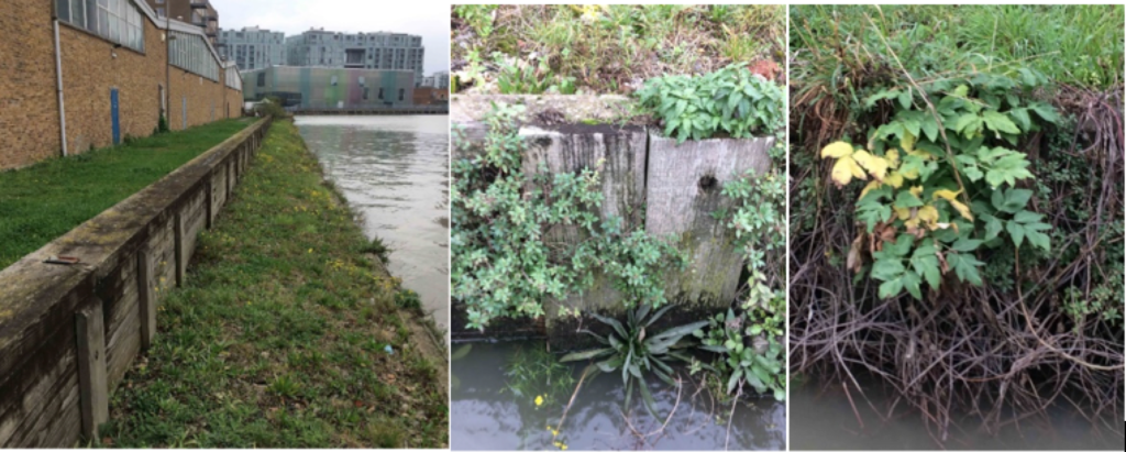
Figure 5: Deptford Creek. Left to right: Northward view over part of the extensively re-profiled land just south of the Laban Centre. Pellitory-of-the-wall growing out of the creek wall, the partially submerged flowers are those of narrow-leaved ragwort. Garden angelica emerging from a nursery of brambles.
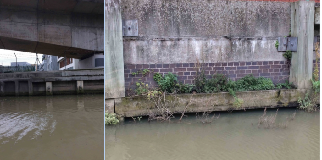
Figure 6: Deptford Creek. Left: Section of creek wall impacted by overhanging wall top, as well as adjoining transport link. Right: Timber constructed wall brace with some, rather limited, vegetation along the upper surface.
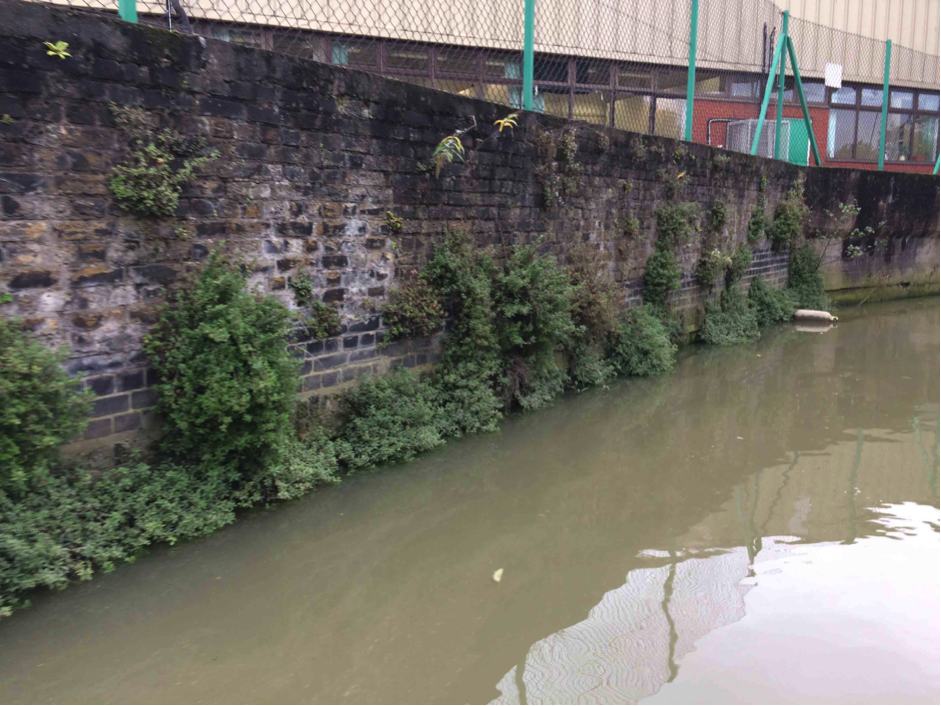
Figure 7: Deptford Creek. Old brick creek wall dominated by pellitory-of-the-wall. It is likely that detailed survey work of walls such as this would reveal a wide diversity of bryophytes, lichens and fungi, as well as invertebrates.
Invertebrates:
The habitat type is well-sorted gravel or coarse sand (LS.LCS.Sh.Pec). The invertebrate assemblage present in the sediment scraped from the timbers of this feature suggests that the succession of this habitat has progressed to the 5th and final tier (Figure 8) on the Joint Nature Conservation Committee classification system which suggests that this habitat succession has progressed well and this site is doing very well. The habitat found through this system corresponds with the gravel backfill.
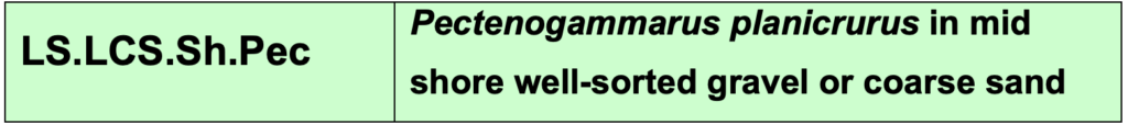
Figure 8: Joint Nature Conservation Committee classification system code for the habitat based on the invertebrate assemblage.
3.2 Geomorphology
Approximately 67% of the accretable area has accreted with sediment above the design level (Figure 9).
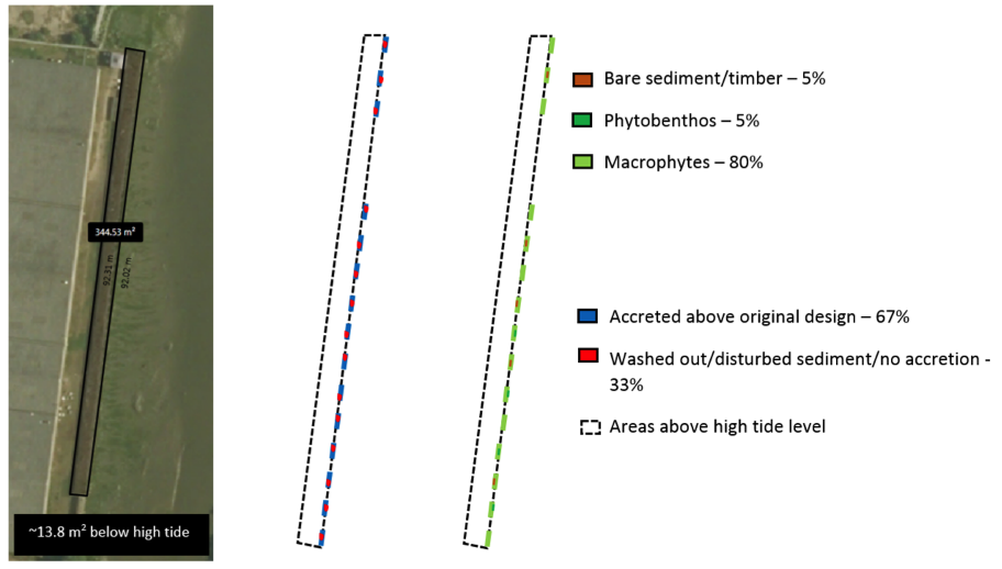
Figure 9: Schematic showing geomorphology and basic ecology.
Contributing reasons for this include:
- Sheltered from wave energy;
- Planters accrete sediment well but narrow, horizontal timbers are likely to be subject to higher fluvial flows washing sediment away.
Accretable areas do not include the majority of the plan view of this structure as it has a terrace above high spring tides but the fronting planters (Figure 10) and horizontal timbers (Figure 11) do. Planters form the greater majority of the horizontal surfaces below high tide level and therefore accounts for the 67%.
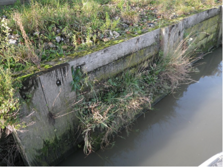
Figure 10: Deptford Creek vertical wall renewal: planters with well-established vegetation and therefore indicating good sediment accretion.
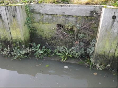
Figure 11: Deptford Creek vertical wall renewal: timbers with relatively poor sediment accretion (bare wood visible).
4. Social, Litter, Safety and Navigation
4.1 Social
Questionnaires were completed adjacent to the estuary edge sites that had public access. The questions sought to understand how the Thames and intertidal green spaces were viewed and understood. These questions tell us about different value sets that can be measured. Surveys were conducted on Deptford Creek footbridge and are representative of all three Deptford creek estuary edges. Figure 12 shows us that residents and passers’ by (samples size:12 people; almost 1:1 male:female ratio; aged between 15-75 years old) were on average positive about the terraces and the Thames in general.
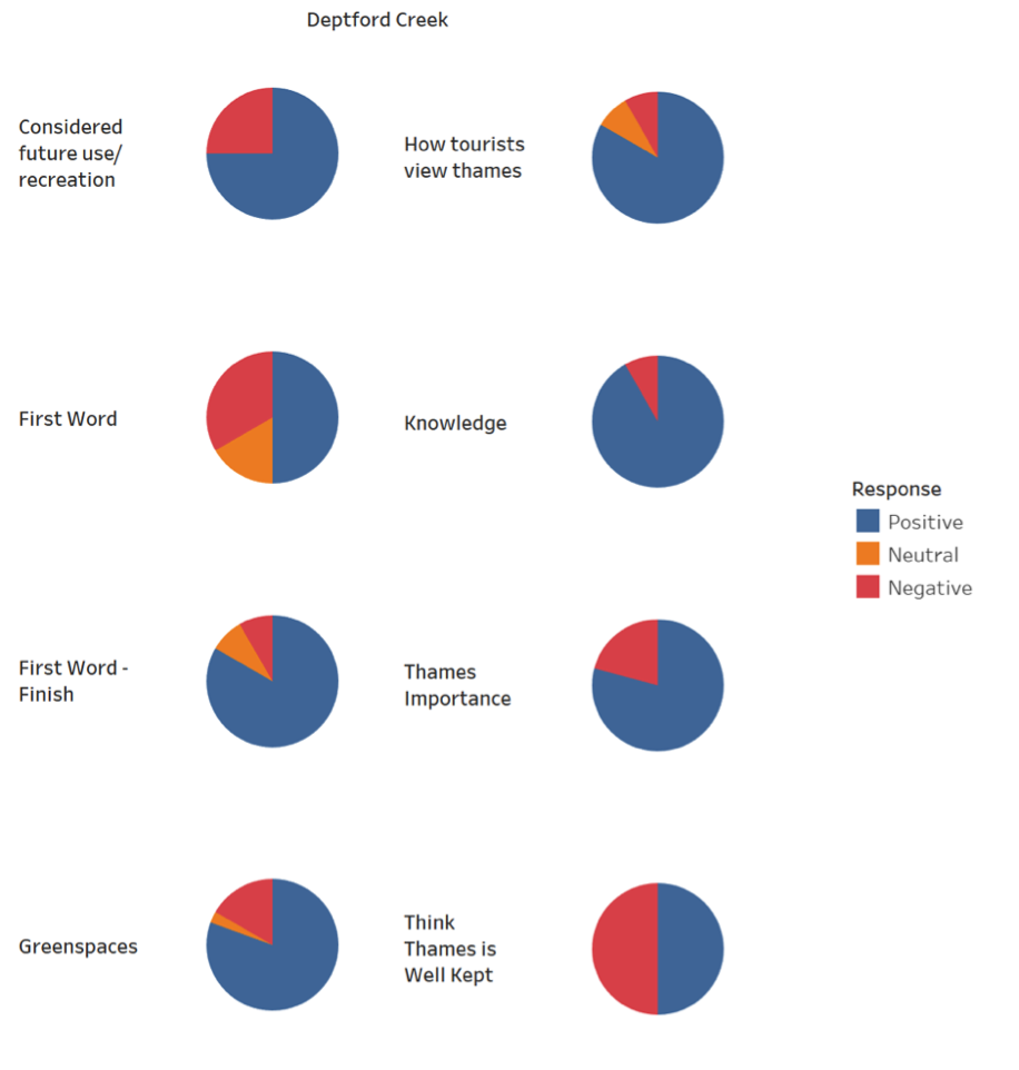
Figure 12: Pie charts showing distribution of positive, negative and neutral comments from passers-by regarding varying aspects of the estuary edge feature.
As part of the questionnaire, we asked them what the first word that came in to their head was when thinking of the Thames at the beginning of the interview and again at the end after they’d answered all the questions. This showed a positive perception shift from neutral or negative to positive. This indicated that education and interpretation of the site would increase people’s connection to the terrace and the river.
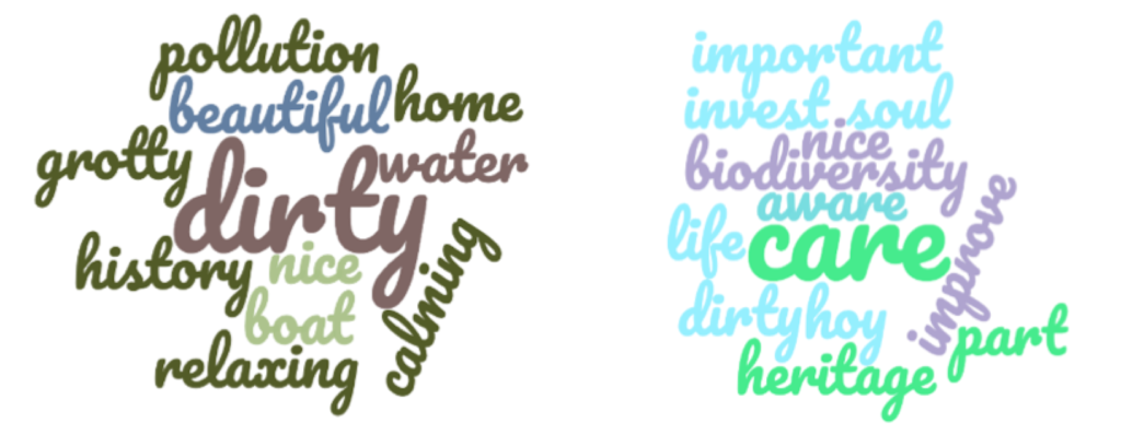
Figure 13: First (left) and last (right) words of what respondents think of the river asked at the beginning and end of a questionnaire.
4.2 Litter
The intertidal surfaces of this feature are limited in extent and therefore have not gathered litter. Although good for avoiding litter on the sections which are valuable for estuarine ecology, the terrestrial terrace above has suffered from some collection, likely blown here or thrown over the flood wall (Figure 14).
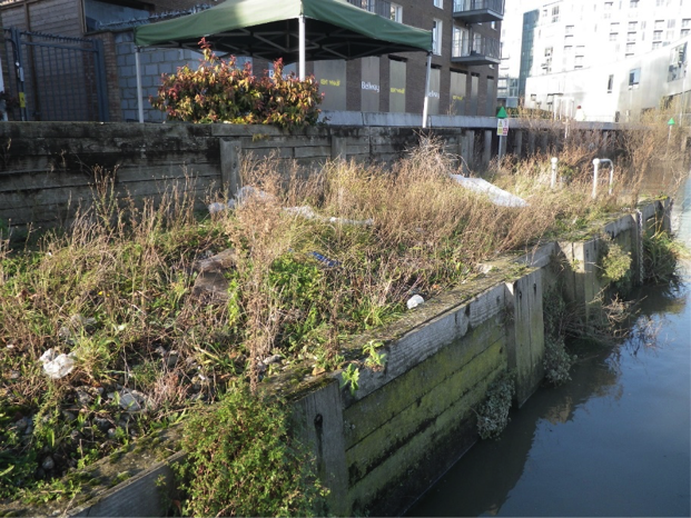
Figure 14: Litter on the terrestrial terrace on the northern end of the Deptford Creek Vertical Wall Renewal in Winter 2017/18. Note that the limited horizontal inundatal areas are clear of litter.
4.3 Safety and Navigation
This site appears to be deteriorating, items becoming free and falling into the river is not appropriate for long term design of any structures in the estuary and creek.
There is no lighting or signage on this structure, however when originally constructed it did not present a navigational hazard for passing vessels as it doesn’t protrude significant or have a significant cut into.
5. Engineering
| Structural Element | Assessed Condition | Expected lifespan | Recommendations |
| Steel sheet pile river wall* | No obvious signs of distress from distance. | 20 to 50 | |
| Timber cladding | Some timbers now missing or about to fail (Figure 14). | 0 to 10 | |
| Sand bank | Not seen | N/A |
Table 2: Table showing individual engineering elements of the main Deptford Creek Vertical Wall Renewal Site (not the planters 60m further south on the brick walls) and their expected lifespan.
*where it was not possible to assess the element, assumptions have been made that it was designed for inter-tidal environment with a 50 year design life.
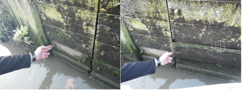
Figure 15: Timbers either missing or about to fail in the Deptford Creek Vertical Wall Renewal. Photograph taken in Winter 2017/18. Source: Environment Agency.
5.1 Potential engineering improvements/ refinements
No requirement to avoid use of vertical/reflective structures since this location is sheltered from significant wave action. However:
- Establish a suitable monitoring and maintenance regime for the intertidal habitat/ structures/ foreshore (monitor foreshore/ nearshore levels to identify any future potential risk of lowering which could result in undermining of the wall).
- Use a different bracket system for habitat timbers to prevent their loss.
6. Conclusions
6.1 Within the first 11 Years (1997 to 2008)
- The scheme was considered a success in ecological, social and economic terms.
- The ‘vertical beach’ rapidly colonised with a fauna and flora similar to that which had colonised the original wall.
- Kingfishers were seen investigating the bank, but no breeding occurred. This may be the result of people using the river edge or the height of the water.
- A good range of sizes in fish species were seen.
6.2 Within the next 10 Years: 2008 to 2018
- The scheme continues to be a success in ecological and social terms (the economic element was not considered in this update).
- Fish surveys show that, estuary wide, the greatest number of individuals use tidal tributaries creeks and therefore providing estuary edge features is very important in these locations. There are fish using these features.
- Invertebrate and geomorphology surveys show that gravel and sand filled planters work very well.
- Due to the lack of inundatal horizontal surfaces, the site performs well for litter.
- The site has deteriorated and now is not performing well for safety and navigation.
- High social value suggest that improved interpretation could enhance their experience and educate passers-by.
- The missing and failing habitat timbers points to high level design principle number 13: regarding the lifetime of the structure needing to be the same as the projected lifespan of the development (this is particularly important regarding timber).
- A monitoring and maintenance regime is required.