Case Studies
Dartford Creek Erosion Protection
Grid Reference TQ5351577063

Figure 1: Map of Estuary edges sites pinpointing Dartford Creek Erosion Protection; inset graphics include Google Earth aerial photo of site and chart extract of Site (heights in metres relative to Chart Datum).
This example is arguably not an enhancement for biodiversity as the creek already existed and it is purely soft engineering to prevent erosion/movement of a meander. However, useful learning can be made from the brushwood fascines and brush-packing which, unlike the 3 most downstream Barking Creek Sites: A13 Frogmore, Beckton Sewage Treat Works and Creekmouth was used in conjunction with metal wire over the top.
1. Introduction
1.1 Site Conditions Summary
| Salinity (during low fluvial flows) | ~15‰ (Wade, Hawes and Mulder, 2017) |
| Date of construction | 2007 |
| Tidal Range | 5.9m |
| Percentage of area accreted above design level | 100 % |
| Degree of exposure to waves: | Low |
| Degree of exposure to currents: | Medium (inc fluvial currents) |
| Max wave height | ?PLA? |
| Slope direction | East-South-East |
| Slope angle | Mudflat: 1 in 3 normal to flow, near horizontal parallel to flow. |
| Average Whole Structure lifespan | No engineering elements to inspect. |
Table 1: Site conditions summary.
1.2 Site Characteristics
- Dartford Creek is the tidal reach of the rivers Darent and Cray stretching from Dartford and Crayford to the confluence with the tidal Thames.
- With salinities in the range of 15‰ true saltmarsh exists here.
- Meander bends and their low flow channels are active possibly as a result of historical straightening but other geomorphological responses e.g. sea level rise, may be at play.
- Both watercourses are chalk streams. The Darent, which the larger of the two is predominately rural. it should not be ‘flashy’ in its flow. Due to the size of the catchment however, the impact of fluvial currents is still put as medium.
- Two migrating meander bends (one 800m upstream of the confluence with the Thames, to be referred to as ‘the northern section’, and the other 1.4km upstream, to be referred to as ‘the southern section’) were endangering the earth raised flood defence and hence putting the Darent Industrial park and designated freshwater marshes at increased risk of tidal flooding.
1.3 What the Environment Agency did
- Works to the northern and southern sections were near identical. The northern section was approximately 300m long and the southern section was approximately 150m long.
- A backing sheet steel pile wall was placed at the rear of the saltmarsh to act as a backstop.
- Timber fascines and brushwood packing were installed in a similar way to the Barking Creek sites: A13 Frogmore, Beckton Sewage Treatment works and Creekmouth. They were secured in place with timber stakes.
- Metal wire was placed over the top and accretion left to occur.
- No pre-planting was conducted.
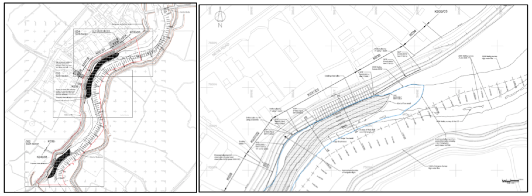
2. Aerial photo and as-built drawings: plan view and cross-sectional view
This site consists of two non-contiguous sections, with a gap of around 250m. The repair methods were identical and therefore they remain listed as a single site.

Figure 2: Aerial view of site (Google 3D image from 2018) (a) Southern (upstream) section and 250m northwards (b) Northern section.
Artist’s impression combining ecology and engineering using a photograph not available for this site.
(a)
(b)
(c)
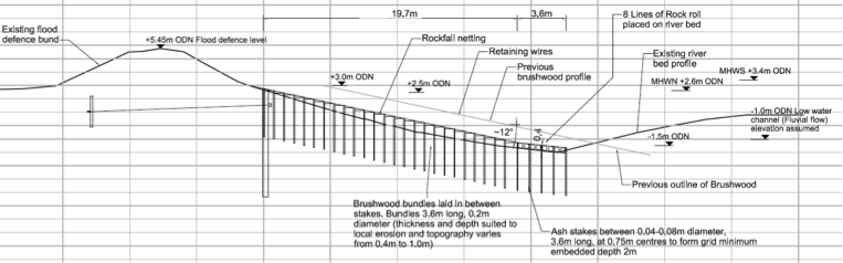
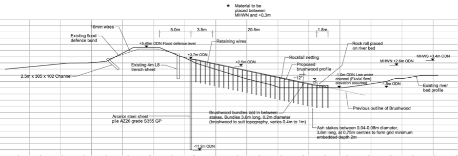
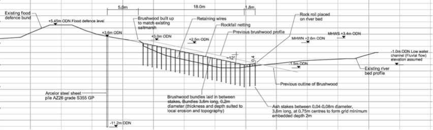
Figure 3: Section views for the northern section from as built drawings (a) Section A-A shown on Figure 4c (b) Section B-B shown on Figure 4b and (c) Section C-C shown on Figure 4b. Section view drawings for the southern section are not available.
(a)(b)
(c)(d)
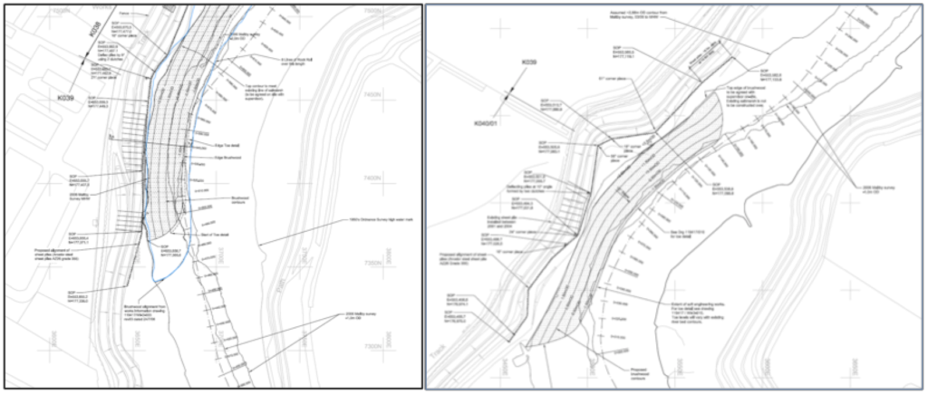
Figure 4: Plan view from as built drawings (a) Overview showing both the northern and southern sections in a single drawing (b) Northern part of the northern section (c) Southern part of the northern section and (d) Southern section.
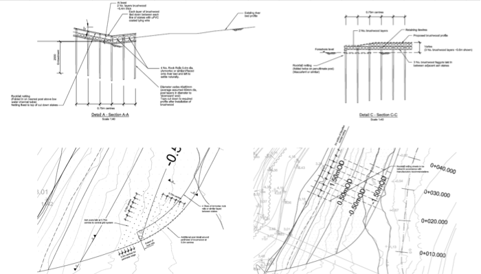
Figure 5: Brushwood detail for sections A-A and C-C shown on Figures 4b and c.
3. Environmental
3.1 Inundation
During larger tides (spring) bottom of the bank repairs are exposed and fully covered. During smaller (neap) tides the lower edge of the bank repair has water on it.

Figure 6: cross section of elevation of constructions (heights in CD)
3.2 Biodiversity
Adjacent Site:
The next nearest site where biodiversity was measured is Barking Creek, Creekmouth which is 10.5 km further up-estuary. The salinity will be significantly lower there. However, as the feature created at Barking Creekmouth was a curving creek it will have lower energy in terms of waves and currents than Dartford Creek Erosion Protection. In term of similarity of construction, Barking Creek, A13 Frogmore was probably the most similar to Dartford Creek, Erosion Protection but biodiversity was not assessed at A13 Frogmore.
Fish:
No fish surveys were conducted at this site. See Barking Creek, Creekmouth for the nearest similar site.
Botany:
No surveys of the flora were conducted at this site. See Barking Creek, Creekmouth for the nearest similar site.
Invertebrates:
No invertebrate samples were taken at this site. See Barking Creek, Creekmouth for the nearest similar site.
3.2 Geomorphology
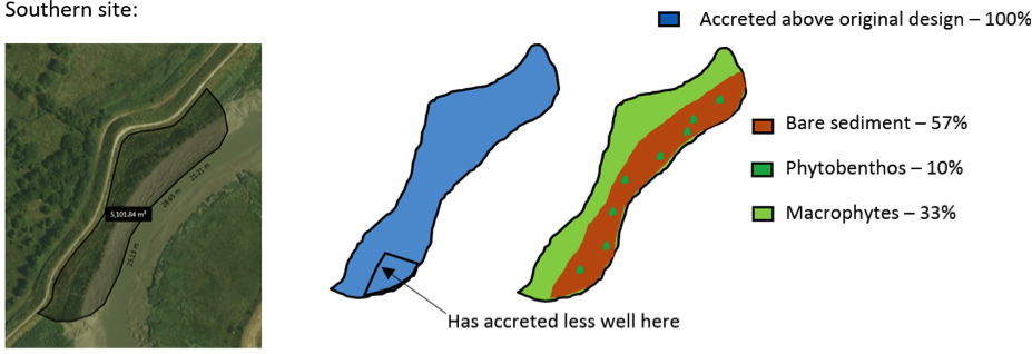
At both the northern and southern sections 100% of the accretable area has accreted with sediment above the design level (Figure 7). Note that as this was previously erosional, this denotes success in the erosion protection. However, some patches have not accreted as well as others and here the metal wire used in construction is exposed above the mudflat surface (Figures 8 and 9).
True saltmarsh exists here and this is not cliffing in the two erosion protected areas, indicating stability (Figure 10).
(a)
(b)
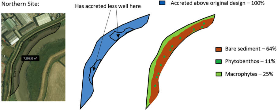
Figure 7: Schematic showing geomorphology and basic ecology for (a) Southern site and 250 m further north (b) Northern site.
Contributing reasons for this include:
- Brushwood and timber facines provide enough reduction in currents and promote enough sediment deposition to overcome the meander migration.
- Plentiful sediment supply.
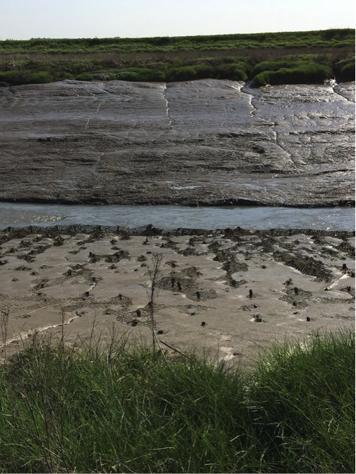
Figure 8: Dartford Creek Erosion Protection, northern section, looking east in Spring 2018, showing an area which has not accreted as well as others and/or it has sunk as the brushwood has biodegraded and hence the metal wire used in construction is exposed above the mudflat surface. Source: Environment Agency.
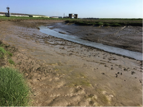
Figure 9 (left): Dartford Creek Erosion Protection, northern section, looking north in Spring 2018, showing the best accretion being in the centre of this section with exposed metal wire either side. Source: Environment Agency.
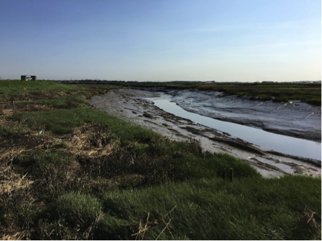
Figure 10 (right): Dartford Creek Erosion Protection, southern section, looking north in Spring 2018, showing no cliffing of saltmarsh which is generally indicative of no erosion. Source: Environment Agency.
4. Social, Litter, Safety and Navigation
4.1 Social
The site is not easily publicly accessible and therefore no social surveys were completed as part of this review.
4.2 Litter
A few pieces of litter were observed but the feature was generally clear (Figure 11).
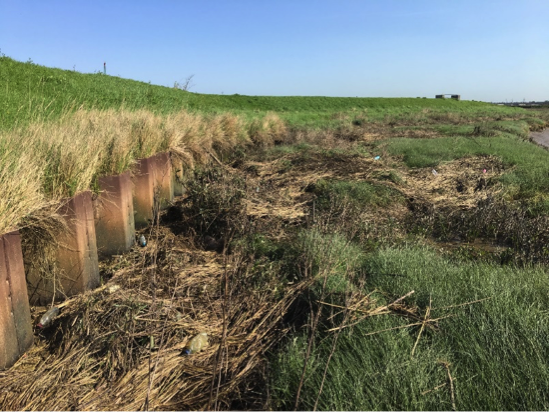
Figure 11: Dartford Creek Erosion Protection, southern section, looking north in Spring 2018, showing very little litter. Source: Environment Agency.
4.3 Safety and Navigation
This feature has been constructed in the channel of the river and therefore creates a higher risk to navigational safety. However due to the creek bed levels already limiting navigation the impact would be lower than such a scheme in the main Thames Estuary.
The nature of maturity means that the hazel spikes currently protrude from the sediment and could cause damage to passing, although infrequent, vessels.
5. Engineering
No detailed land-based inspection undertaken to date since there are no significant engineering
6. Conclusions
6.1 Within the first 11 Years (2007 to 2018):
NB: (This site was not in the original, 2008 Estuary Edges document)
- The erosion protection is performing well and promoting mudflat accretion across the whole site. Its biodiversity value should be better than a hard engineered solution. It should also not radically increase erosion elsewhere in the channel (a principle of geomorphology).
- Where accretion is not as extensive and/or the mudflat has sunk as the brushwood has biodegraded, the metal wire is exposed which will be a hazard to wildlife. This leads to the text in high level design principle 12 regarding avoiding metal wire in designs as well as the text placed in the sustainability and adaptability
- Protruding hazel spikes poses a hazard to navigation and vessels and should be either pushed lower or have the tops cut off.