Case Studies
Barking Creek, Beckton Sewage Treatment Works
Grid Reference TQ4516982496
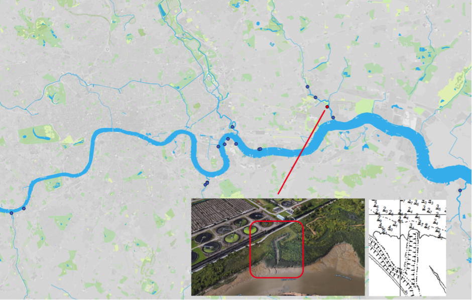
Figure 1: Map of Estuary edges sites pinpointing Barking Creek, Beckton Sewage Treatment Work; inset graphics include Google Earth aerial photo of site and chart extract of Site (heights in metres relative to Chart Datum).
1. Introduction
1.1 Site Conditions Summary
| Salinity (during low fluvial flows) | ~9‰ at creek mouth (open estuary) (Wade, Hawes and Mulder, 2017) |
| Date of construction | 2012 |
| Tidal Range | 1.6m |
| Percentage of area accreted above design level | 100 % |
| Degree of exposure to waves: | Low |
| Degree of exposure to currents: | Low |
| Max wave height | |
| Slope direction | Multiple (Creek creation) |
| Slope angle | 1 in 6 normal to created creek, 1 in 50 along created creek bed. |
| Average Whole Structure lifespan | Not applicable (not engineered) |
Table 1: Site conditions summary.
1.2 Site Characteristics
- Located on the right bank of the tidal River Roding (also known as Barking Creek), 1.2km upstream of the confluence with the Thames.
- Within a nature reserve formed on Thames Water’s land.
- Some vessel traffic to nearby industry but this will produce limited wake as it will proceed very slowly in the confined creek.
- No fetch for the prevailing west-south-westerly wind.
- The salinity of 9‰ at the mouth of Barking Creek is likely to be very similar here.
1.3 What Thames Water did
- Rebuilt the earth flood embankment approximately 40m further inland in a horseshoe shaped longer alignment.
- Excavated a curved creek and lined it with timber fascines secured with stakes in the same style at Barking Creek Creekmouth.
- Allowed natural establishment of vegetation. No pre-planting was conducted.
2. Aerial photo and as-built drawings: plan view and cross-sectional view
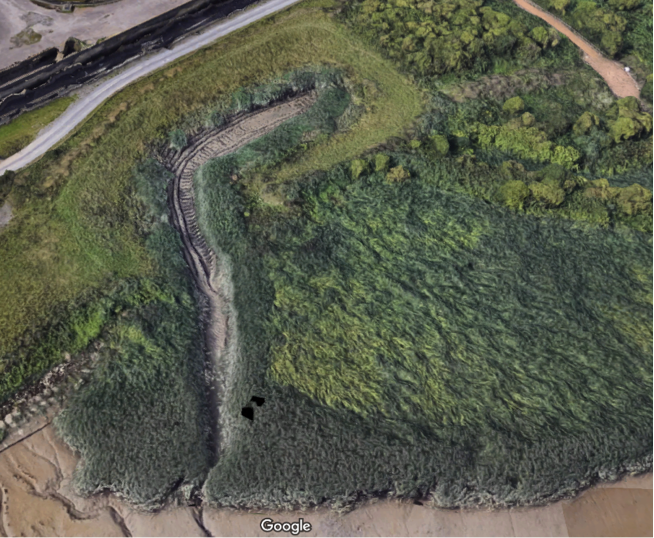
Figure 2: Aerial view of site (Google 3D image from 2018)
Artist’s impression combining ecology and engineering using a photograph not available for site.
Section and plan views from as built drawings not available for this site.
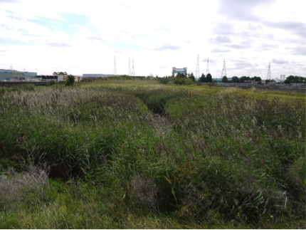
Figure 3: Photograph in lieu of all drawings: Barking Creek, Beckton Sewage Treatment Works looking south east in Summer 2017. Source: Environment Agency.
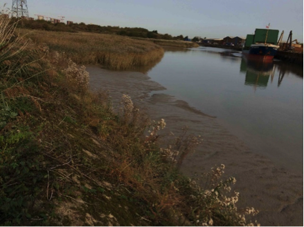
Figure 4: Photograph in lieu of all drawings: Barking Creek, Beckton Sewage Treatment Works looking north in Summer 2017, showing open creek width and vessel types in use. Source: Mark Spencer.
3. Environmental
3.1 Inundation
The immediate area of river in front of the set back is the banks of the creek, which are shallow made of silt and mud.
During larger tides (spring) the terrace has water on it while the top of the terrace is covered for almost seven hours. During smaller (neap) tides the terrace has water on it for just over nine hours and the top of the terrace is only reached for six and a quarter hours.
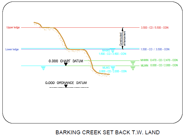
Figure 5: cross section of elevation of constructions (heights in CD)
3.2 Biodiversity
Adjacent Site:
Barking Creek creekmouth, located just 760m further downstream on the tidal River Roding is a near identical site but on the opposite bank.
Fish:
Sampling was only conducted within the feature at this site and not in the water in front of the feature. Species found included: juvenile Bass (Micropterus salmoides), Common Goby (Pomatoschitus microps), Flounder (Platichthys flesus), European Eel. (Anguilla anguilla) In comparing data to past studies, this site has now become a significant bass nursery.
Botany:
This site has limited access and therefore was difficult to observe. However, a colony of common reed (Phragmites australis) was seen from the access point. At the southern point of the site, sea aster (Aster tripolium), wild celery (Apium graveolens) and sea club-rush (Bolboschoenus maritimus) were identified. These are all species associated with brackish water, so it was not unusual to spot them growing at the site. Future sampling would need safety ropes and sampling points earlier in the year before die-off starts. For details of all species recorded, please see the botany report 2017. Links in the Further Reading section.
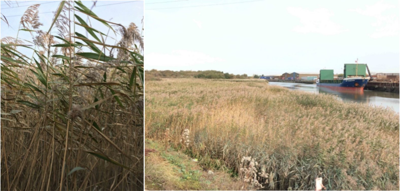
Figure 6: Becton Sewage Works. Main site dominated by extensive coverage of very vigorous common reed.
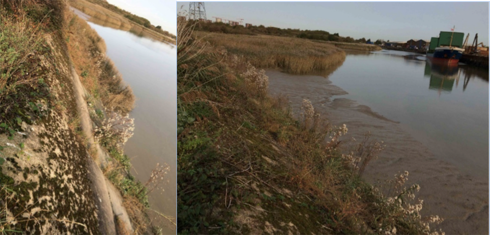
Figure 7: Becton Sewage Works. Southern portion of site, a steep concrete river wall with a narrow strip of saltmarsh plants at the base, especially sea aster and wild celery.
| Planted | Natural Colonised | Dominant | Notable species |
| Common Reed (Phragmites australis) | Wild Celery (Apium graveolens) | Common Reed (Phragmites australis) | |
| Sea Aster (Aster tripolium ssp. tripolium var tripolium) | |||
| Sea Club Rush (Bolboschoenus maritimus) |
Table 2: Showing a selection of the planted, assumed naturally colonised, dominant and notable species found at the site. For details of all species found, see the botany report 2017.
Invertebrates:
Invertebrate data, although collected, has not been processed for this site. See Barking Creek, creekmouth where the site is near identical.
3.2 Geomorphology
100% of the accretable area has accreted with sediment above the design level (Figure 8). A distinct gulley has formed at the downstream end (Figure 9) which is indicative of its relatively young 6-year age: as accretion continues in the rest of the creek, the gulley is likely to infill significantly.
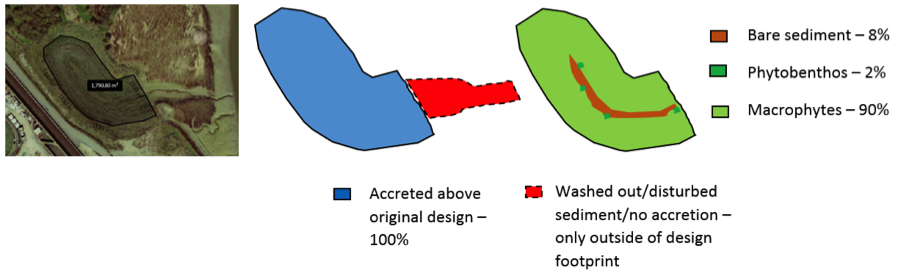
Figure 8: Schematic showing geomorphology and basic ecology.
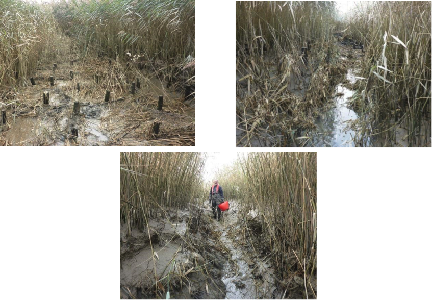
Figure 9: Barking Creek, Becton Sewage Treatment Works, sediment deposition in the centre of the creek and the gulley at the downstream extent. Summer 2017 (5 years since construction). Source: Steve Colclough.
Contributing reasons for this include:
- Creek is curved and very sheltered, set well back from the main tidal Roding.
- Entrance to the creek faces away from the prevailing south-south-westerly wind.
- Limited vessel traffic on the creek and what there is will proceed slowly due to confined creek location (Figure 9).
4. Social, Litter, Safety and Navigation
4.1 Social
The site is not easily publicly accessible and therefore no social surveys were completed as part of this review.
4.2 Litter
A few pieces of litter observed but the feature was generally clear. There are no further photographs which justify this.
Contributing reasons for this:
- Mouth of creek faces away from the prevailing west-south-westerly wind.
4.3 Safety and Navigation
While as a design now it has become established has had minimal impact to the navigation within the creek, the method and timing of the breach caused a significant release of sediment into the creek.
5. Engineering
No detailed land-based inspection undertaken to date since there are no significant engineering structures.
Potential engineering improvements / refinements
N/A
6. Conclusions
6.1 Within the first 6 Years (2012 to 2018):
- The site is deemed to be a great success:
- Good sediment accretion.
- Significant nursery habitat for young Bass.
- Typical flora including brownfield site species outside of the tidal range.
- Little litter.
- No hazard to navigation now it is established.
- No future recommendations.