Case Studies
Barking Creek, Creekmouth
Grid Reference TQ4556981831
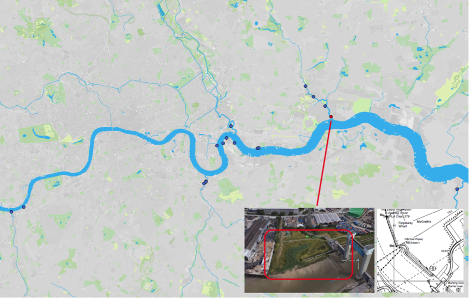
Figure 1: Map of Estuary edges sites pinpointing Barking Creek, Creekmouth; inset graphics include Google Earth aerial photo of site and chart extract of Site (heights in metres relative to Chart Datum).
1. Introduction
1.1 Site Conditions Summary
| Salinity (during low fluvial flows) | ~9% at creek mouth (open estuary) (Wade, Hawes and Mulder, 2017) |
| Date of construction | 2006 |
| Tidal Range | 1.6m |
| Percentage of area accreted above design level | 100% |
| Degree of exposure to waves: | Medium |
| Degree of exposure to currents: | Low |
| Max wave height | |
| Slope direction | Multiple (Creek creation) |
| Slope angle | 1 in 12 normal to created creek, 1 in 29 along created creek bed. |
| Average Whole Structure lifespan | Not applicable (not engineered) |
Table 1: Site conditions summary.
1.2 Site Characteristics
- Located on the right bank of the tidal River Roding (also known as Barking Creek), immediately upstream of the confluence with the Thames.
- On land used to construct the Barking Creek barrier and now turned into a park.
- Creek over 50m wide and subject to 1.6m tidal range.
- Some vessel traffic to nearby industry but this will produce limited wake as it will proceed very slowly in the confined creek.
- Fetch from the prevailing south-south-westerly wind could cause some wind waves.
1.3 What The Environment Agency did
- Excavated a curved creek into the high ground with slopes less than 1 in 7 and capped them with clay.
- Sweet Chestnut posts installed and brushwood bundles delivered.
- ‘Brushpacking’ (500mm brushwood fascines packed over whole mud surface) installed between 2500mm long Sweet Chestnut posts (installed at 600mm centres) retained by biodegradable tensioned coir twine on slopes up to Mean High Water Neaps. Fascine diameter graded down to 200mm at low tide mark.
- Pre-planting was conducted: clumps of locally sourced cell-grown Common Reeds were introduced onto the lower slopes. These were smothered with some 40cm of sediment in just six months.
- Steeper upper slopes retained by brushwood bundles installed as fascines between Sweet Chestnut posts on alternate sides at 600mm centres. Diameter of faggot bundles used, increasing from 200mm to 500mm down the slope. Retained by biodegradable tensioned coir twine.
- Upper fascine-stabilised slopes seeded with proprietary seed mix at 2g/m2 augmented with locally collected seed of Red Fescue, Sea Aster and Sea Arrow-grass.
- Trench of rock rolls installed at the top of each side of revetment slopes for bracing, but still essentially a naturalised design.
- Wider site includes subsoil-based wildflower meadow, eco-centre and interpretation boards for visitors.
2. Aerial photo and as-built drawings: plan view and cross-sectional view
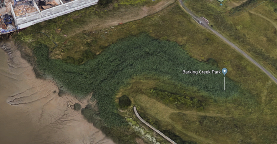
Figure 2: Aerial view of site (Google 3D image from 2018)
Artist’s impression combining ecology and engineering using a photograph not available for site.
Section and plan views from as built drawings not available for this site.
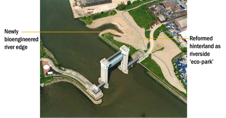
Figure 3: In lieu of plans, aerial view of site just after completion in 2006 showing the unvegetated creek at high tide. Source: Estuary Edges 2008 document.
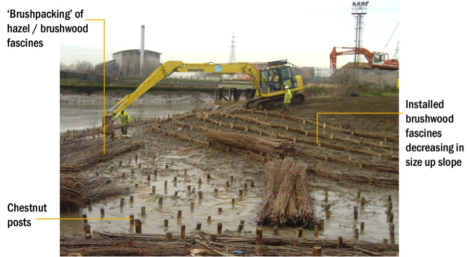
Figure 4: in lieu of plans, photograph looking west showing the detail of the brushwood fascines and brushpacking whilst under construction in 2006. Source: Estuary Edges 2008 document.
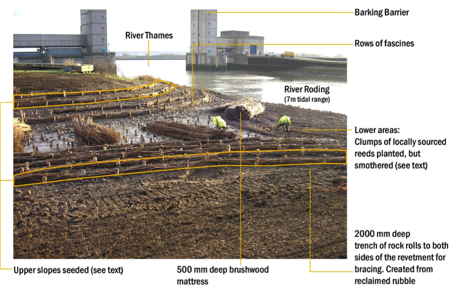
Figure 5: in lieu of plans, photograph looking south showing the detail of the brushwood fascines and brushpacking whilst under construction in 2006. Source: Estuary Edges 2008 document.
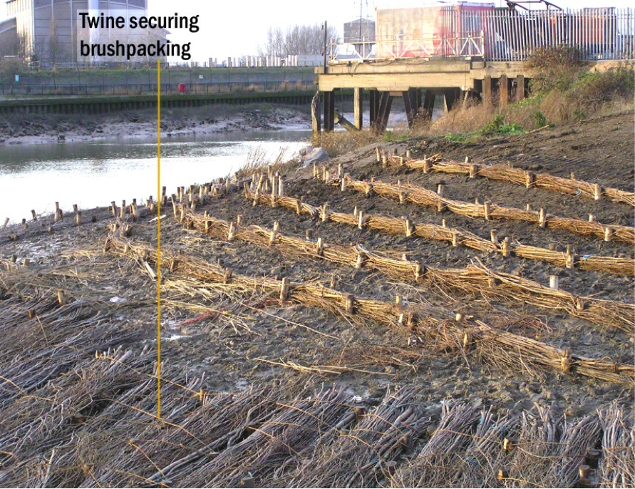
Figure 6: in lieu of plans, photograph looking west showing the fixing detail of the brushpacking whilst under construction in 2006. Source: Estuary Edges 2008 document.
3. Environmental
3.1 Inundation
The immediate area of river in front of the reed bed is the mouth of Barking Creek and the adjacent barrier. The area is not navigable during low tides.
The lower part of the slope is always covered with some water. During larger tides (spring) the top of the slope has water on it for seven hours. During smaller (neap) tides the top of the slope is reached for six and a half hours.
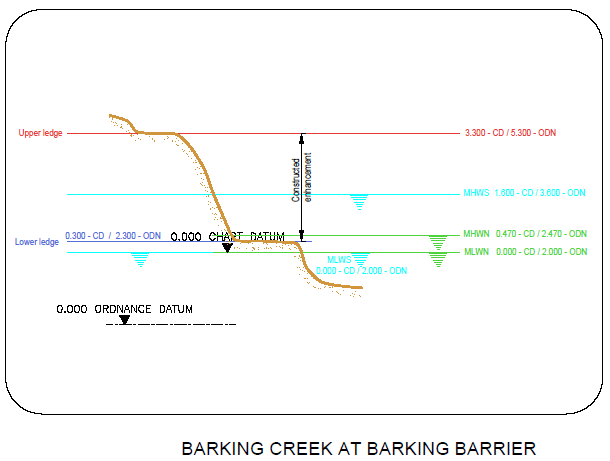
Figure 7: cross section of elevation of constructions (heights in CD)
3.2 Biodiversity
Adjacent Site:
Barking Creek, Beckton Sewage Treatment Works, located just 760m further upstream on the Tidal River Roding is a near identical site but on the opposite bank.
Fish:
Sampling was only conducted within the feature at this site and not in the water in front of the feature. Species found included: juvenile Bass (Micropterus salmoides), Common Goby (Pomatoschitus microps), Flounder (Platichthys flesus), and European Eel (Anguilla anguilla). In comparing data to past studies, this site has now become a significant bass nursery.
Botany:
This site has limited access and therefore was difficult to observe due to the height and vigour of the dominant species common reed (Phragmites australis). Observations to the area were completed immediately adjacent to the creek foreshore.
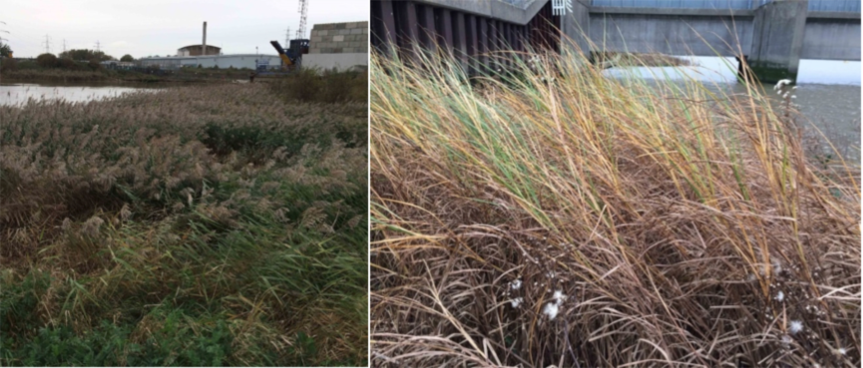
Figure 8: Barking Barrier Park. Left: Northward view over part of the extensively re-profiled land with inlet, now largely invisible due to common reed growth. Right: Colony of sea club-rush growing on creek foreshore.
There were healthy populations of sea club-rush (Bolboschoenus maritimus). The upper foreshore supported a diverse range of brown-field site plants such as the non-native narrow-leaved ragwort (Senecio inaequidens). Within the daily tidal range of the creek several typical saltmarsh plants were found: sea beet (Beta maritima ssp. maritima), sea aster (Aster tripolium) and wild celery (Apium graveolens). Notably also sea mayweed (Tripleurospermum maritimum) and lesser sea-spurrey (Spergularia marina) as this was the only site surveyed where these were found. For details of all species recorded, please see the botany report 2017. Links in the Further Reading section.
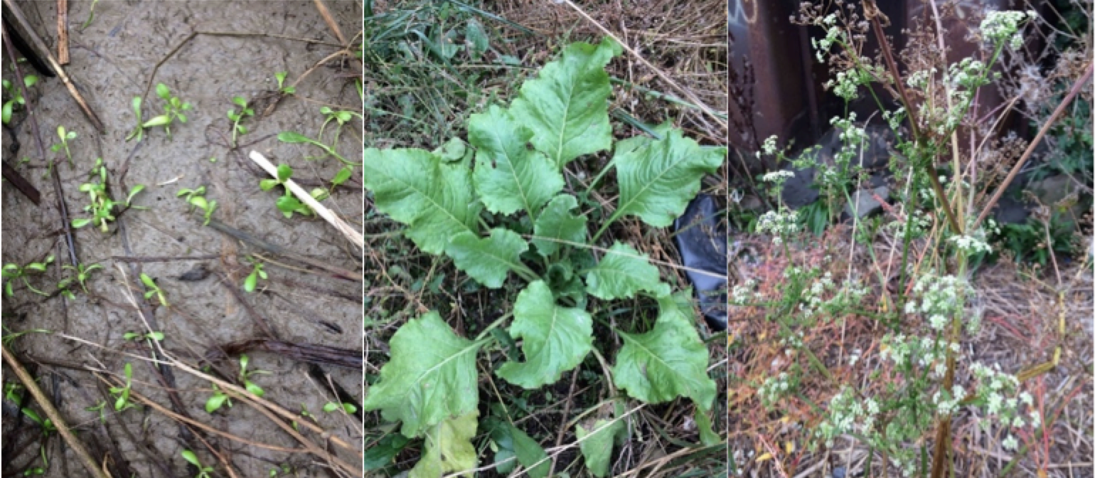
Figure 9: Barking Barrier Park. Left to right: seedlings of sea aster. Overwintering rosette of sea beet. Late flowering plant of wild celery.
| Planted | Natural Colonised | Dominant | Notable species |
| Common Reed (Phragmites australis) | Wild Celery (Apium graveolens) | Common Reed (Phragmites australis) | Sea Mayweed (Tripleurospermum maritimum) |
| Sea Aster (Aster tripolium ssp. tripolium var tripolium) | Lesser Sea-Spurrey (Spergularia marina) | ||
| Sea Beet (Beta maritima ssp. Maritima) | |||
| Sea Club Rush (Bolboschoenus maritimus) | |||
| Narrow-leaved Ragwort (Senecio inaequidens) |
Table 2: Showing a selection of the planted, assumed naturally colonised, dominant and notable species found at the site. For details of all species found, see the botany report 2017.
Invertebrates:
The invertebrate assemblage present suggests that the succession of this habitat has progressed to the 6th tier (Figure 10) of the 6 possible on the Joint Nature Conservation Committee classification system and is therefore performing very well.

Figure 10: Joint Nature Conservation Committee classification system code for the habitat based on the invertebrate assemblage.
3.3 Geomorphology
100 % of the accretable area has accreted with sediment above the design level (Figure 11). Unlike Barking Creek, Beckton Sewage Treatment works, there is a less well-developed gulley at the downstream end, indicative that the site has had more time to fill with sediment (Figure 16).
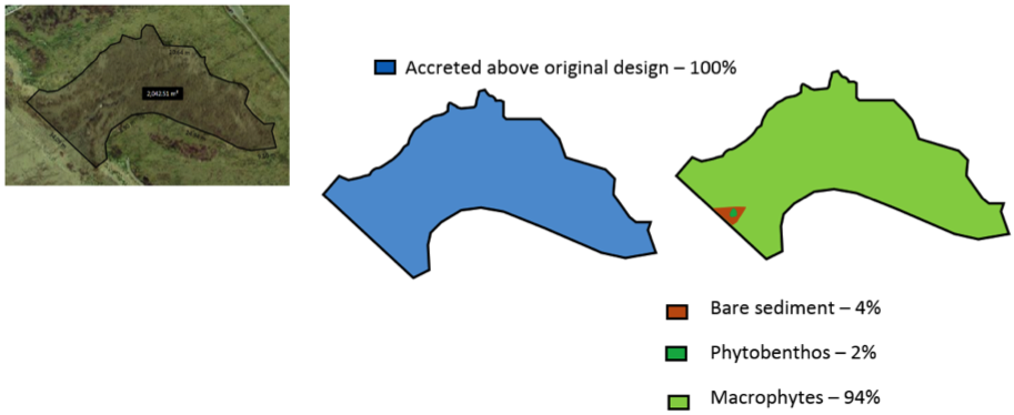
Figure 11: Schematic showing geomorphology and basic ecology.
Contributing reasons for this include:
- Despite the creek facing into the prevailing south-south-westerly wind, wind waves not appear have affected sediment accretion: the creek is curved and set well back from the main tidal Roding.
- Limited vessel traffic on the creek and what there is will proceed slowly due to the relatively confined creek location.
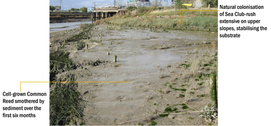
Figure 12: Barking Creek, creekmouth: looking north west over the lower slopes showing 0.4 m of sediment accretion ½ a year after construction.

Figure 13: Barking Creek, creekmouth: looking north east over the upper slopes showing rapid establishment of Sea Club-rush ½ a year after construction.
Figure 14: Barking Creek, Creekmouth: Full extent of creek when viewed from park showing good coverage of vegetation in Spring 2018 (12 years since construction). Source: Environment Agency.
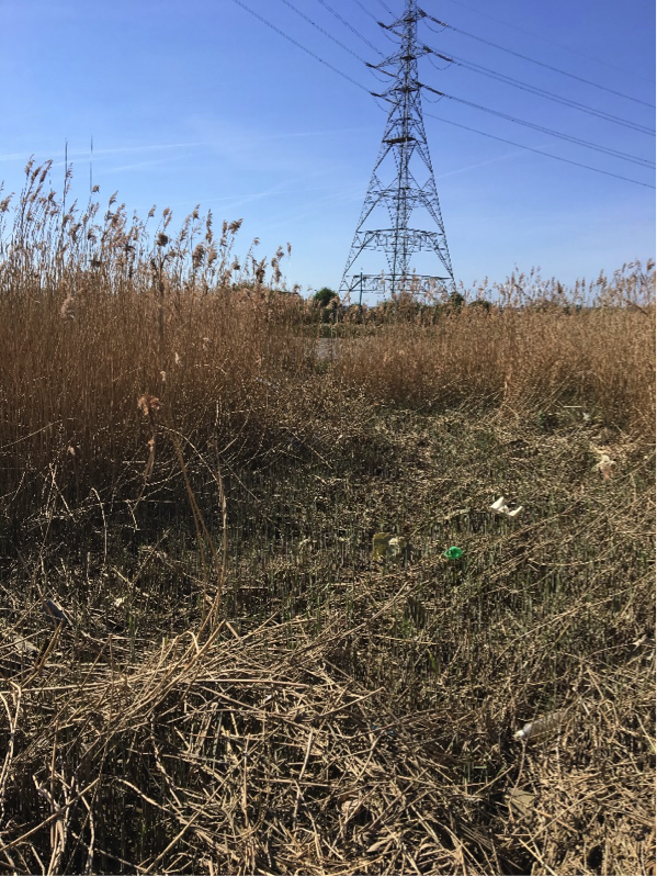
Figure 15: Barking Creek, Creekmouth: Central creek, looking west in Spring 2018 (12 years since construction), showing well established vegetation. Source: Environment Agency.
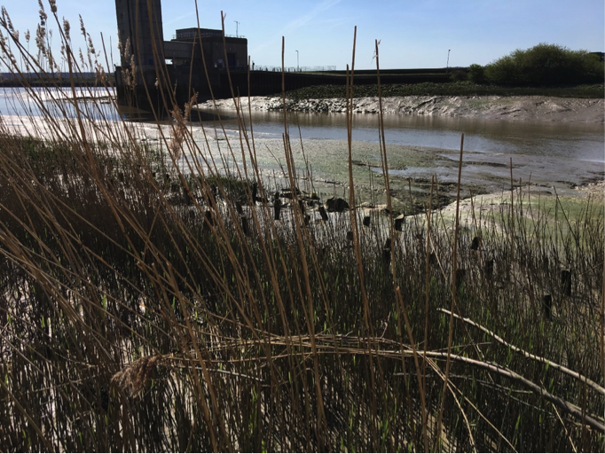
Figure 16: Barking Creek, Creekmouth: Exit of the creek to the Tidal Roding in Spring 2018 (12 years since construction) showing a less well-developed gulley than Barking Creek, Beckton Sewage Treatment work. Source: Environment Agency.
4. Social, Litter, Safety and Navigation
4.1 Social
The site is not easily publicly accessible and therefore no social surveys were completed as part of this review.
4.2 Litter
In the north western corner of the site, litter was found in high density: it was difficult to walk through this area without stepping on litter (Figures 17 and 18). In other areas, such as the central creek, there was less litter but it was still present (Figure 19).
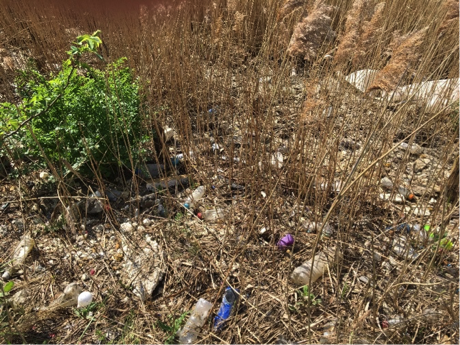
Figure 17: High density of litter in the north west corner of Barking Creek, creekmouth, Spring 2018. Source: Environment Agency.
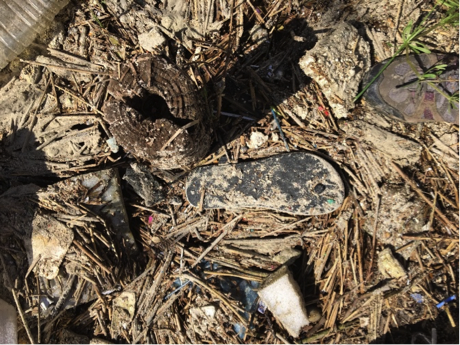
Figure 18: Close up on the high density of litter in the north west corner of Barking Creek, creekmouth, Spring 2018. Source: Environment Agency.

Figure 19: Lower density of litter in the central creek, looking east in Spring 2018. Source: Environment Agency.
4.3 Safety and Navigation
The proximity of the edge of the habitat creation and the navigational channel could the impact capacity maintain the channel for navigational safety in future. This should be further towards the edge of the channel, allowing for the navigable area to be maintained.
5. Engineering
No detailed land-based inspection undertaken to date since there are no significant engineering structures.
Potential engineering improvements / refinements
N/A
6. Conclusions
6.1 Within the first 2 Years (2006 to 2008):
- Natural colonisation of Sea Club-rush extensive on the upper slopes, stabilising the substrate but overwhelming the planting. This leads to design advice under the Wildlife, Planting and Greenspace section to allow natural colonisation wherever possible.
- After 16 months, a wide variety of plants present, with abundant self-sown Sea Aster and strongly spreading Common Reed at higher tidal levels.
- Plentiful supply of fine sediment and net accretion/erosion balance achieved at lower tidal levels.
- Stable vegetation establishment anticipated in the long term, the lowest fringe being colonised by Sea Club-rush.
- Extensive use of the embayment by juvenile fish, especially Sea Bass.
- Considered highly successful and beneficial in ecological, social and economic terms.
6.2 Within the next 10 Years: 2008 to 2018
- The extensive gathering of litter has led to advice in the litter section to orientate creek mouths away from the prevailing wind direction.
- Otherwise the site continues to be a success with:
- Good sediment accretion.
- Fully evolved habitat based on the invertebrates found.
- Significant nursery habitat for young Bass.