Case Studies
Royal Wharf, Eastern Terrace
Grid Reference TQ4099979727
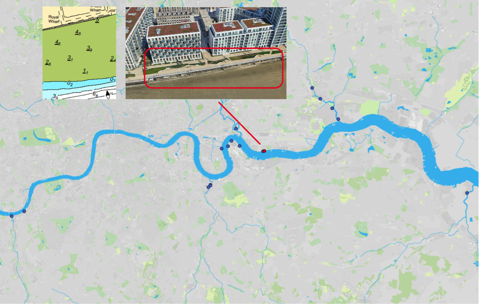
Figure 1: Map of Estuary edges sites pinpointing Royal Wharf, Eastern Terrace; inset graphics include Google Earth aerial photo of site and chart extract of Site (heights in metres relative to Chart Datum).
1. Introduction
1.1 Site Conditions Summary
| Salinity (during low fluvial flows) | ~7.5‰ (Wade, Hawes and Mulder, 2017) |
| Date of construction | 2014 |
| Tidal Range | 6.6m |
| Percentage of area accreted above design level | 60% |
| Degree of exposure to waves: | High |
| Degree of exposure to currents: | Medium (straight section of estuary) |
| Max wave height | |
| Slope direction | South |
| Slope angle | Near horizontal normal and parallel to flow. |
| Average Whole Structure lifespan | 20-50 Years |
Table 1: Site conditions summary.
1.2 Site Characteristics
- Formerly known as Minocco wharf, this previously industrial site was redeveloped into high density housing and apartments in the 2010s and rebranded as Royal Wharf.
- Open estuary, currents are likely to be significant although the watercourse is fairly straight at this point running west-east.
- The fetch of around 600m for the prevailing south-south-westerly could generate some minor wind waves.
- This site is situated in a higher wash area for vessel and is likely to see waves of 1.2m. However, the river in this area is very wide with extensive foreshores in front of the enhancements which should help to dissipate the energy of the waves and likely not to see additional reflected wash.
- The area is used by commuter vessels and most inland commercial operations including tugs and tows.
1.3. What the developers did
- The original fronting sheet steel pile wall cut down to foreshore level.
- Sheet steel piles were used to form the rear flood defence wall just over 1.5m further inland. The rear flood defence wall was capped with concrete.
- A foundation to the terrace was constructed of mass concrete, 1m in depth. This did not include additional drainage.
- Timber was used to both clad the concrete foundation at the front and form a retaining wall by extending this wall upwards by 0.6m above the concrete found. This was the same format used as Deptford Creek Saxon Wharf and Deptford Creek Thanet Wharf.
- The terrace was lined with geotextile and filled
- Pre-planting of phragmites was conducted.
2. Aerial photo and as-built drawings: plan view and cross-sectional view
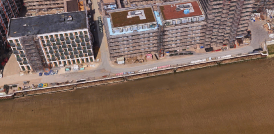
Figure 2: Aerial view of site (Google 3D image from 2018)
Artist’s impression combining ecology and engineering using a photograph not available for this site.
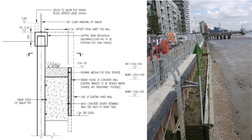
Figure 3: Section view from as built drawings and equivalent photograph (Source of photograph: Environment Agency). Photograph looking east, Winter 2018 (4 years since construction) shows scour and poor plant growth.
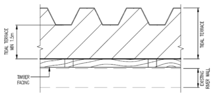
Figure 4: Plan view from as built drawings.
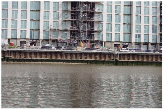
Figure 5: Photograph equivalent to a front view giving further information on the design. Source: Jacobs/TEAM2100.
3. Environmental
3.1 Inundation
During larger tides (spring) the terrace has water on it for over two hours and 22 minutes while smaller (neap) tides the terrace has water on it for 32 minutes.
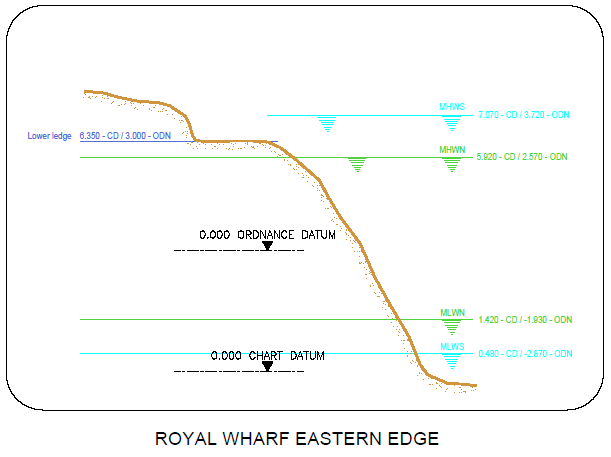
Figure 6: cross section of elevation of constructions (heights in CD)
3.2 Biodiversity
Adjacent Site:
Royal Wharf Western Embayment is immediately west of this site. It has had some limited biodiversity sampling conducted but not fish. Greenwich peninsula terraces north east, at approximately 2km further up estuary, is the nearest comparable site where all biodiversity sampling was conducted. It will be slightly less saline although is open estuary and will therefore be subject to the same fluid dynamics.
Fish:
Fish weren’t able to be measured at this site as the site is too low (relative to the upper shoreline) and not very wide. See Greenwich peninsula terraces north east for the nearest comparable location.
Botany:
Plant life was dismal in this area, likely due to the section being too low (relative to the upper shoreline), as a result the planted common reed (Phragmites australis) were experiencing prolonged periods underwater and significant scouring. It is believed fish and other aquatic life are feeding on the plants, making it difficult for them to grow and thrive.
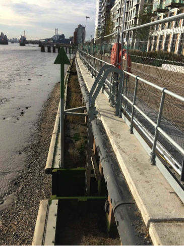
Figure 6: Royal Wharf: Lower terrace dominated by bare mud and gravel with very limited growth of common reed.
Invertebrates:
Invertebrates were not sampled at this site. See Royal Wharf Western Embayment which is immediately west of this site.
3.3 Geomorphology
Just 30% of the accretable area has accreted with sediment above the design level (Figure 7).
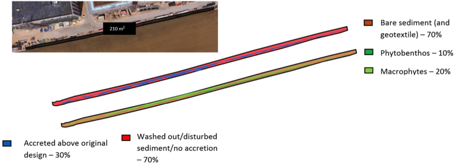
Figure 7: Schematic showing geomorphology and basic ecology.
Contributing reasons for this include:
- High vessel wake and minor wind waves causing reflection of the rear wall (see earlier Figure 3).
- Not recessed back from those current which exist.
- Water logging: impermable concrete foundation, fill too shallow.
- Lower elevation (0.3m lower) than the adjacent Royal Wharf Western Terrace and the inability for sediment to accrete upward with the high wave energy.
4. Social, Litter, Safety and Navigation
4.1 Social
The site was not publicly accessible at the time of the surveys and therefore no social surveys were completed as part of this review. It is recommended that these be completed once construction is complete.
4.2 Litter
Almost no litter was observed at Royal Wharf Eastern Terrace (see earlier Figure 3).
Contributing reasons for this:
- Little to no trapping effect from vegetation or groynes combined with high wave energy, high wave reflection and some current energy.
- Likely high degree of maintenance as construction is still underway and homes are still for sale.
4.3 Safety and Navigation
The site is a considerable distance from the navigational channel across a shallow foreshore, and therefore protected by the lack of water depth in front of it. This means that the site is not a significant concern or navigational risk. Marking and lighting of the site is helpful and consideration of any change of use in the area.
5. Engineering
| Structural Element | Assessed Condition | Expected lifespan | Recommendations |
| Sheet steel pile wall and concrete capping | Has a design life of 110 years. | > 50 years | No comments. |
| Mass concrete gravity retaining wall. | Has a design life of 110 years. | > 50 years | No comments. |
| Existing sheet steel piles cut down to foreshore level* | Questionable as to whether this is integral to the design | 20 to 50 years | Detailed inspection (including pile thickness measurement)
and comparison of existing foreshore level and prediction of future foreshore levels is recommended. |
| Recycled timber cladding/retaining wall | Inspector commented that this has no structural integrity but this forms the retaining wall for the sediment. | Not assessed. | No comments. |
*where it was not possible to assess the element, assumptions have been made that it was previously designed for inter-tidal environment with a 50-year design life but has since deteriorated.
Table 2:Table showing individual engineering elements of Royal Wharf Eastern Terrace and their expected lifespan.
Potential engineering improvements/ refinements
- Cutting down pre-existing structures to provide toe details presents a risk due to uncertainties/ lack of available information on original date of installation, design details and design assumptions (with respect to issues such as loading and assumed minimum foreshore levels). It is therefore difficult to predict residual life of these vital structural elements.
- Avoid vertical structures, in particular interfaces/ corners between vertical structures, which result in wave reflection and localised erosion.
- Avoid narrow intertidal terraces immediately adjacent to vertical reflective structures which are likely to result in localized scour and prevent establishment of intertidal habitat.
- Design intertidal terraces to consider potential intertidal habitat zones, wave exposure (including vessel generated waves) and future climate change (sea level rise and increased fluvial flow).
- Provide greater depth of gravel/ alluvium and drainage on terraces.
- Install rock rolls/ gabions: i) immediately inshore of steel sheet toe piles; ii) riverward of rear steel sheet piles and iii) at interfaces/ corners between vertical structures to reduce scour due to wave reflection off vertical structures.
- Install pre-grown intertidal habitat planting (which is tolerant to wave action) with suitable substrate.
- If necessary, replace softwood with recycled hardwood throughout to increase residual life.
- Establish a suitable monitoring and maintenance regime for the intertidal habitat/ structures/foreshore (monitor foreshore/ nearshore levels to identify any future potential risk of lowering which could result in undermining of the river wall at the toe).
6. Conclusions
6.1 Within the first 4 Years (2014 to 2018)
- There is limited biodiversity data to prove how well this site is performing, but the lack of vegetation and scour suggests that it is not performing well.
- Improvements would be:
- A deeper terrace (horizontal distance) combined with rock armour and/or biodegradable geotextile on the fill surface to succeed in the high energy open estuary environment. This guidance has been added to the geomorphology
- Deeper fill and therefore drainage. The impermeable relatively shallow mass concrete foundation was also found to be a problem for drainage at Deptford Creek Saxon Wharf and to a small degree at Deptford Creek Thanet Wharf, Unlike Deptford Creek Thanet Wharf, the south facing nature of this site did not outweigh the poor drainage. This guidance has been added to guidelines specific to vegetated intertidal terraces.
- Terraces in the high energy open estuary must be constructed to the correct level as there is no opportunity for sediment accretion to form a higher level. This guidance has been added to guidelines specific to vegetated intertidal terraces.
- The site performed well for litter.
- The site performs well for safety and navigation.
- A monitoring regime is required.