Case Studies
Point Wharf, Greenwich
Grid Reference TQ3898180300
This example is arguably encroachment as it fills in and builds upwards on the original Thames foreshore. Although the learning from this site is useful from an ecological and geomorphological point of view, it is strongly recommended not to copy the design unless encroachment is necessary for reasons such as engineering or contamination reasons.
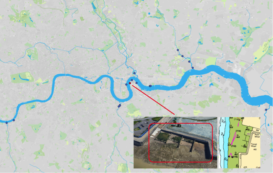
Figure 1: Map of Estuary edges sites pinpointing Point Wharf, Greenwich; inset graphics include Google Earth aerial photo of site and chart extract of Site (heights in metres relative to Chart Datum).
1. Introduction
1.1 Site Conditions Summary
| Salinity (during low fluvial flows) | ~5.2% (Wade, Hawes and Mulder, 2017) |
| Date of construction | Early 2000s (exact date unknown) |
| Tidal Range | 6.6m |
| Percentage of area accreted above design level | 60 % |
| Degree of exposure to waves: | High |
| Degree of exposure to currents: | Medium |
| Max wave height | |
| Slope direction | West-North-West |
| Slope angle | 1 in 3 normal to flow, 1 in 11 parallel to flow |
| Average Whole Structure lifespan | 20-50 Years |
Table 1: Site conditions summary.
1.2 Site Characteristics
- Prevailing south-south-westerly wind could cause wind wave here.
- Inside of meander bend so sheltered from currents.
- Recessed/bay so also sheltered from currents and waves.
- This site is situated in a higher wash area likely to see waves of 1.2m. However, the river in this area is very wide with extensive foreshores in front of the enhancements which should help to dissipate the energy of the waves and likely not to see additional reflected wash.
- The area is used by commuter vessels and most inland commercial operations including tugs and tows.
1.3. What the developers did
From inspection (as built drawings cannot be located for this site), it is apparent that the following was conducted, possibly as part of the replacement of the sheet steel pile backing flood walls:
- Constructed 4 hardwood timber groynes forming 4 bays (Figure 2)
- Constructed lines of sheet steel piles to enclose 3 of the bays to varying shore normal depths.
- Placed to the limit of the top of the sheet steel piles, covered with a non-biodegradable geotextile and then a plastic mesh on top to prevent bird life eating the plants.
- Pre planting was conducted: It is likely that phragmites plants were inserted within gaps.
- Used rebar hooks to hold the geotextile and plastic mesh in place.
2. Aerial photo and as-built drawings: plan view and cross-sectional view

Figure 2: Aerial view of site (Google 3D image from 2018).
Artist’s impression combining ecology and engineering using a photograph not created for this site.
As built drawings could not be located for this site.
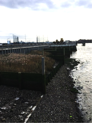
Figure 3: Closest photograph to a section view drawing. Winter 2018. Source: Environment Agency.As built drawings could not be located for this site.
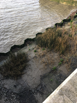
Figure 4: Closest photograph to a section view drawing, Winter 2018. Source: Environment Agency.
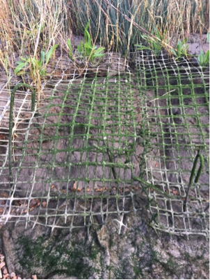
Figure 5: Photograph showing specifics of non-biodegradable geotextile, plastic mesh and hook rebar.
3. Environmental
3.1 Inundation
The immediate area of river in front of the terrace dries during low tides and is predominantly gravel foreshore.
The top of the wall is always dry. During larger tides (spring) the terrace has water on it for over three hours while in smaller (neap) tides the terrace has water on it for 39 minutes.
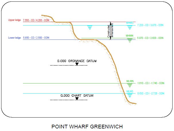
Figure 6: cross section of elevation of constructions (heights in CD)
3.2 Biodiversity
Adjacent Site:
West India Dock Phragmites Bed is directly opposite. Wave, current and light availability may be different but otherwise it is similarly located in the open estuary.
Fish:
Sampling on the terraces was not possible due to closure of the Barrier. Seine netting in front of the terrace. The terraces have established stands of vegetation and should provide good cover for fish life. The vertical campshed face to the terraces will dissuade some species such as flounder from penetrating onto the terraces (Colclough et al, 2004). Water drains out through holes in the campsheds, leaving significant ponded areas behind temporarily. Some fish stranding on the terraces is therefore likely.
The community of fish species found through seining included Bass (Dicentarchus labrax), Common goby (Pomatoschistus microps) and a Thin-lipped grey mullet (Liza ramada) is the community known to be present in these reaches of the river in the late summer/early autumn. The capture of a sea horse (Hippocampus hippocampus) was a notable finding due to their rarity locally.
Botany:
Some areas of the terrace remain significantly bare, however there are patches of healthy vegetation. The common reed (Phragmites australis) (figure 15), sea club-rush (Bolboschoenus maritimus), and club rush (Schoenoplectus sp.) were all observed on the site. Two notable finds were the most western example of sea-arrow grass (Triglochin maritimum) recorded in the Thames which seems to be becoming more frequent in the eastern stretches of the Thames and Kattegat orache (Atriplex x gustafssonianus) observed along the upper driftline, an under-recorded saltmarsh plant thay may be more widespread in the Thames estuary than records suggest. There is also a possibility that some of the plants on the Greenwich Peninsula may be the very rare hybrid, S. x carinatus, between common club-rush (S. lacustris) and the now regionally extinct triangular club-rush (S. triqueter). All the Schoenoplectus populations in the Greenwich area need checking thoroughly. For details of all species recorded, please see the botany report 2017. Links in the Further Reading section.
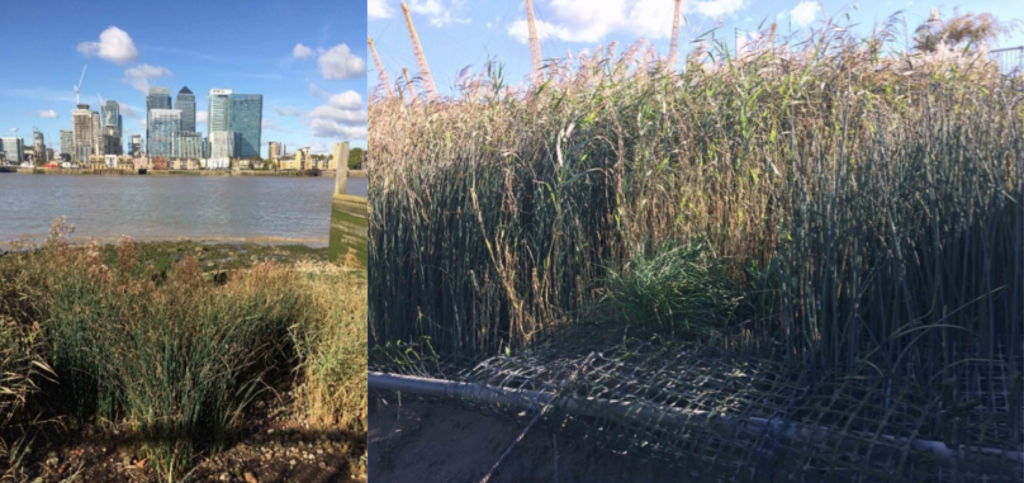
Figure 7: Point Wharf. Left: Mid-section of terrace dominated by club-rush (note grey colouration of stems, indicative of grey club-rush). Right: Lower section of terrace with damaged wire meshwork in foreground and common reed and club-rush to the rear. In the centre foreground is a large plant of sea arrow-grass.
| Planted | Natural Colonised | Dominant | Notable species |
| Sea Club-Rush (Bolboschoenus maritimus) | sea-arrow grass (Triglochin maritimum) | ||
| Common Reed (Phragmites australis) | Kattegat orache (Atriplex x gustafssonianus) | ||
| Club Rush (Schoenoplectus sp.) | hybrid (S. x carinatus) |
Table 2: Showing the planted, assumed naturally colonised, dominant and notable species found at the site. For full details of all species recorded, see the botany report 2017.
Invertebrates:
The habitat type is Hediste diversicolor and Corophium volutator in littoral mud (Ls.LMu.UEst.Hed.CVol). The invertebrate assemblage present suggests that the succession of this habitat has progressed beyond the 6th tier (Figure 8) of 6 on the Joint Nature Conservation Committee classification system. This suggests that this site is performing really well.
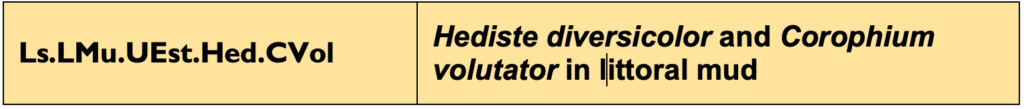
Figure 8: Joint Nature Conservation Committee classification system code for the habitat based on the invertebrate assemblage.
3.3 Geomorphology
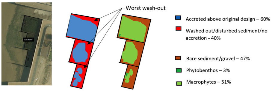
60% of the accretable area has accreted with sediment above the design level (Figure 9). Some cobbles and gravels which are unlikely to be original fill have moved over these terraces.
Contributing reasons for this include:
- Open to wind waves from the South-South Westerly previaling wind.
- Walls in the opposing direction to vessel movement are subject to wave wash and scour at their base (likely the same direction as wind waves).
- Shallow slope.
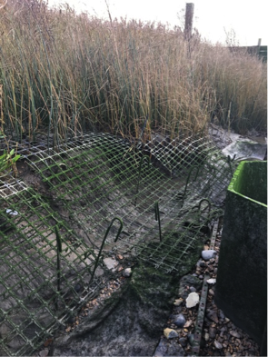
Figure 10: Point Wharf, Greenwich: Scour behind the sheet steel piles front caused by waves, Winter 2018 (years since construction unknown).
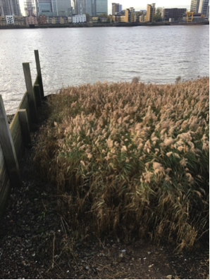
Figure11: Point Wharf, Greenwich: Less scour (and consequential good growth of vegetation) at the upstream ends of the groyne bays, Winter 2018 (unknown numbers of years since construction).
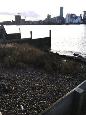
Figure 12: Point Wharf, Greenwich: More scour at downstream ends which is likely to be a result of a mix of vessel and wind generated waves, Winter 2018 (unknown numbers of years since construction). Gravels may have originated from the foreshore if the beach level was higher in front of the sheet steel piles at an earlier point in time.
4. Social, Litter, Safety and Navigation
4.1 Social
Questionnaires were completed adjacent to the estuary edge sites that had public access. The questions sought to understand how the Thames and intertidal green spaces were viewed and understood. These questions tell us about different value sets that can be measured. Figure 13 shows us that residents and passers’ by at Greenwich Peninsula North East and are applicable here (samples size:22 people; 3:1 male:female ratio; aged between 15-75 years old) were on average neutral about the terraces and more negative about the Thames in general.
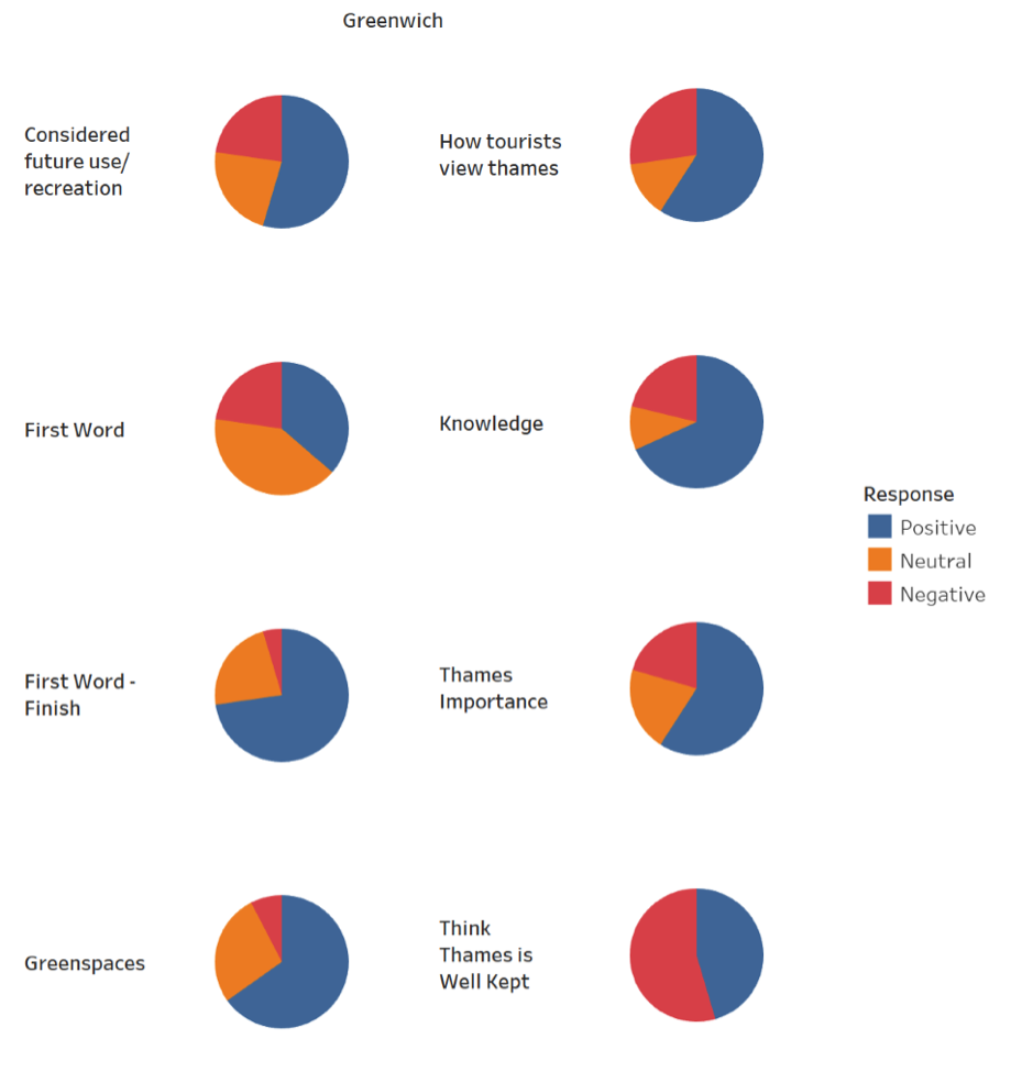
Figure 13: Pie charts showing distribution of positive, negative and neutral comments from passer’s by regarding varying aspects of the estuary edge enhancement.
As part of the questionnaire, we asked them what the first word that came in to their head was when thinking of the Thames at the beginning of the interview and again at the end after they’d answered all the questions (see Figure 14). This showed a positive perception shift from neutral or negative to positive. This indicated that education and interpretation of the site would increase people’s connection to the terrace and the river.
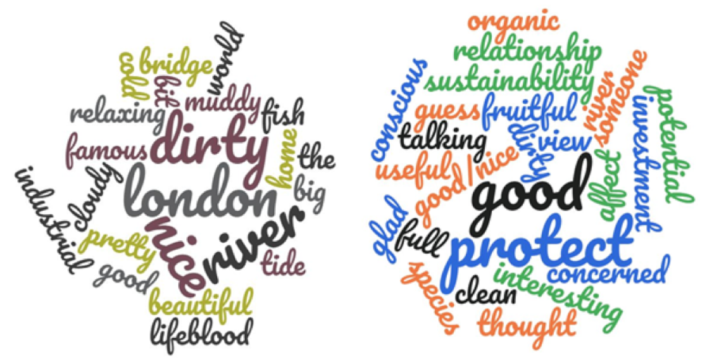
Figure 14: First (left) and last (right) words of what respondents think of the river asked at the beginning and end of a questionnaire.
4.2 Litter
Litter was found in corners and multiple but discrete areas across terrace. No photos taken really demonstrate the degree of litter collection. Likely reasons for the degree of litter collection are:
- Wind and vessel generated waves washing in litter;
- Limited vegetation due to the scour meaning actual less ability to trap litter.
4.3 Safety and Navigation
The orientation of this site to the flow of traffic creates a potential issue with wave energy. The extension along the side of the slipway is not very well marked.
The fixing of the mats did not go to plan and mats floated away before the site was established causing navigational concern.
5. Engineering
| Structural Element | Assessed Condition | Expected lifespan | Recommendations |
| Sheet steel pile wall at toe and at rear* | No comments. | 20 – 50 | N/a |
| Timber groynes (posts and planks)* | Timber unknown | 20 -50 | N/A |
| Geo-grid (plastic mesh) | Failed in a few places. | <20 years | N/A |
*where it was not possible to assess the element, assumptions have been made that it was designed for inter-tidal environment with a 50-year design life.
Table 3:Table showing individual engineering elements of Point Wharf, Greenwich and their expected lifespan.
Potential engineering improvements/ refinements
- Avoid the use of vertical structures, in particular interfaces/ corners between vertical structures, which result in wave reflection and localised erosion.
- Install rock rolls/ gabions: i) immediately inshore of steel sheet toe piles; ii) riverward of rear steel sheet piles and iii) at interfaces/ corners between vertical structures to reduce scour due to wave reflection off vertical structures.
- Consider utilising materials which will bio-degrade once the intertidal habitat has established and rock infill which will be stable under wave exposure conditions without the requirement for gabions (which have a limited lifespan, due to the potential for corrosion/ abrasion).
- Install pre-grown intertidal habitat planting (which is tolerant to wave action) with suitable substrate.
- Establish a suitable monitoring and maintenance regime for the intertidal habitat/ structures/foreshore (monitor foreshore/ nearshore levels to identify any future potential risk of lowering which could result in undermining of the river wall at the toe of the terrace).
6. Conclusions
6.1 Within the first ~15 Years (Early 2000s to 2018)
- The relatively low percentage accretion of sediment on this terrace is thought to be a representation of its location both within a fetch open to wind waves and vessel wake.
- The exposed plastic mesh, geotextile and hook rebar are both a hazard and unattractive leading to high level design principle number 12 to avoid use wire or non-biodegradable materials (e.g. plastics or geotextile) in otherwise natural designs.
- Interesting site for botany with some indicator species of halophyte species occurring further west than anticipated and potential a very rare hybrid
- Despite the amount of scour, the invertebrate data (likely take from an accreting area within the reeds) suggests the site is performing really well.
- This site is fronted by sheet steel piles which present sharp vertical edges which will dissuade bottom dwelling fish such as flounder from accessing it. Under certain times of the year, these piles may occasionally have a gravel beach against them which pushes gravel up and over onto the terraces, but this was not the case at the time of inspection. Although there are some small drainage holes there is a risk of stranding to fish. The guidelines specific to intertidal vegetated terraces and for fish both stress this point.
- The upstream facing wall (opposing the vessel direction) would benefit from fewer sharp interfaces and from the placement of rock armour to prevent scour from vessel generated waves. This is stressed in the Geomorphology
- The site has a fair degree of litter, but this is not bad compared to many other sites. This is likely washed in by the wind and vessel generated waves.
- The site poses some possible wave energy issues impacting safety and navigation.
- A monitoring regime is required.