Case Studies
Mill Pool, River Roding
Grid Reference TQ4390083712
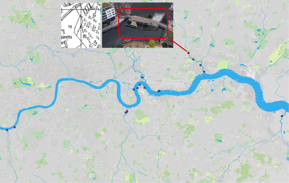
Figure 1: Map of Estuary edges sites pinpointing Mill Pool, River Roding; inset graphics include Google Earth aerial photo of site and chart extract of Site (heights in metres relative to Chart Datum).
1. Introduction
1.1 Site Conditions Summary
| Salinity (during low fluvial flows) | ~9‰ at creek mouth (open estuary) (Wade, Hawes and Mulder, 2017) |
| Date of construction | 2006 |
| Tidal Range | 1.6m (Half tide weir) |
| Percentage of area accreted above design level | 100 % |
| Degree of exposure to waves: | Low |
| Degree of exposure to currents: | Low (open basin reduces fluvial currents) |
| Max wave height | |
| Slope direction | South East |
| Slope angle | 1 in 7 normal to bank, near horizontal parallel to bank |
| Average Whole Structure lifespan | Not assessed. |
Table 1: Site conditions summary.
1.2 Site Characteristics
- Located approximately 3.3km upstream of the mouth of the tidal River Roding (also known as Barking Creek) at a location known as Town Quay.
- This site is unique in that a half tide weir approximately 0.5km downstream means that the tidal zone is narrowed vertically and the natural low tide level is never experienced.
- This site is used by…
- This site is sheltered from vessel wake and there is no fetch to cause wind waves.
- Although around 1/3rd of the River Roding flows through urban north east London, the middle and upper catchment is rural. It is therefore not as ‘flashy’ as some of the south London rivers which are predominately urban. Any residual fluvial currents are likely to be reduced further by the wide basin at Town Quay.
- The salinity of 9‰ at the mouth of Barking Creek but will be significantly lower here due to the fluvial influence.
- Previous the site was a decaying concrete slopes with an invasion of common weeds and relatively low ecological value.
1.3. What the developers did
- Works involved the breaking out of the existing concrete revetment and construction of 3 L-shaped terraces with a maximum slope of 1 in 7 using wooden palisade.
- Terraces were permeable with no concrete beneath.
- The upper two terraces were planted with locally collected riparian seed.
- Pre-planting was conducted: Bottom terrace was planted with Sea Club-rush and Common Reed.
2. Aerial photo and as-built drawings: plan view and cross-sectional view
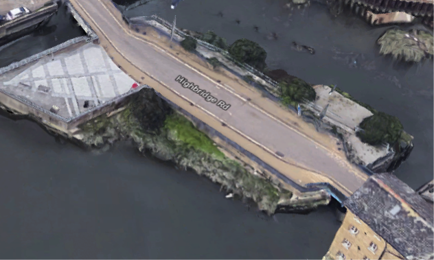
Figure 2: Aerial view of site (Google 3D image from 2018).
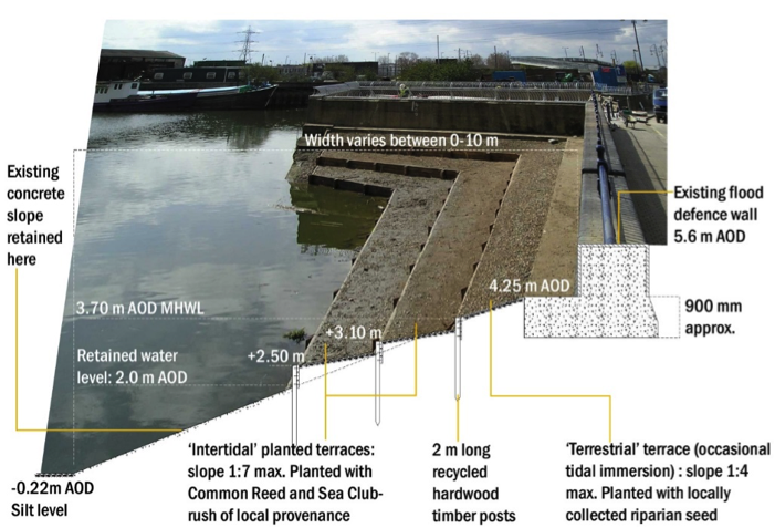
Figure 3: Artist’s impression combining ecology and engineering using a photograph from just after construction in 2006.
As built section and plan views not available for this site.
3. Environmental
3.1 Inundation
The immediate area of river in front of the terraces in the creek shallow with silt and mud and adjacent lock gates.
The lowest ledge of the terrace has water on between eleven hours in small tides to all the tidal cycle in larger tides, while the top of the lowest terrace is covered between in ten hours small(neap) and 27 minutes in large (spring) tides respectively. The top terrace of the three highest point is inundated, between eight and nine hours on neap and spring tides respectively.
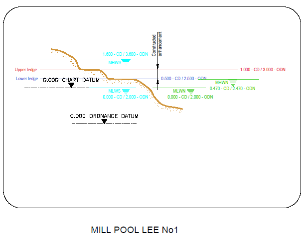
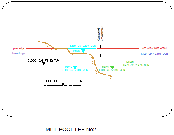
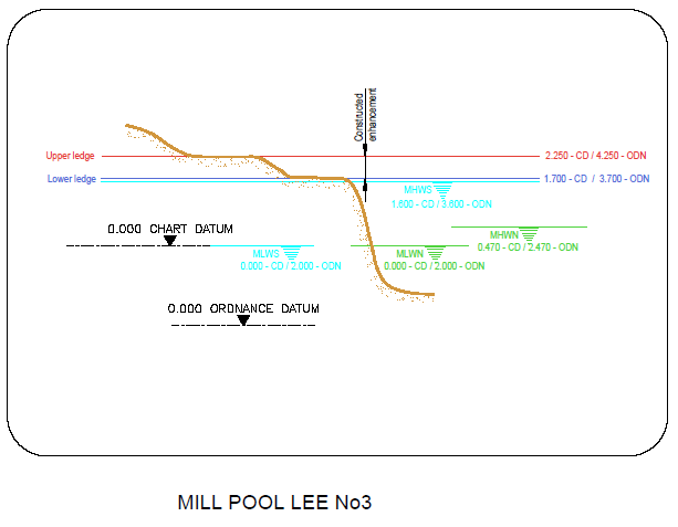
Figure 6: cross section of elevation of constructions (heights in CD)
3.2 Biodiversity
Adjacent Site/Comparable Site:
The next nearest site where biodiversity surveys were conducted was Barking Creek, Beckton Sewage Treatment works 2 km down the Roding. However, the salinity is likely to be significantly higher at Beckton and the style of the estuary edge feature is very different (naturalised set back versus an intertidal vegetated terrace). A more representative comparable site may be therefore be Deptford Creek Thanet Wharf which although 11 km up-estuary and therefore less saline is a very sheltered creek location and south east facing in orientation.
Fish:
Fish weren’t measured at the site. See Deptford Creek Thanet Wharf for a comparable site where they were measured.
Botany:
Flora wasn’t measured at the site. See Deptford Creek Thanet Wharf for a comparable site where it was measured. Although flora wasn’t measured by an ecologist at this site, it is notable that buddleia has taken over along the upper terrace on one side.
Invertebrates:
Invertebrates weren’t measured at the site. See Deptford Creek Thanet Wharf for a comparable site where they were measured.
3.3 Geomorphology
100% of the accretable area has accreted with sediment above the design level (Figure 4).
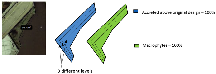
Figure 4: Schematic showing geomorphology and basic ecology.
Contributing reasons for this include:
- Sheltered from both waves and currents.
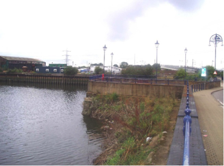
Figure 5: Mill Pool, River Roding, looking west, before enhancement in 2006. Source: Estuary Edges 2008 document.
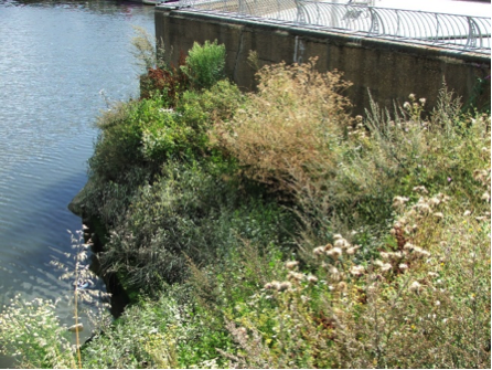
Figure 6: Mill Pool, River Roding, close up of the western section of the terraces in summer 2007 (1 ¼ years after construction) showing well established vegetation. Source: Estuary Edges 2008 document.
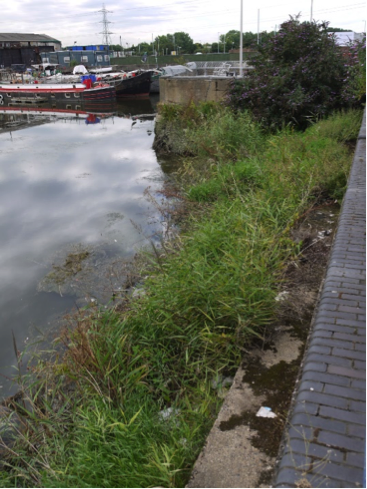
Figure 7: Mill Pool, River Roding, looking west in Summer 2017 (11 years after construction) showing continued well established vegetation but take over by buddleia in one corner. Source: Environment Agency.
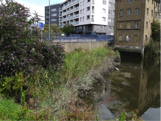
Figure 8: Mill Pool, River Roding, looking east in Summer 2017 (11 years after construction) showing continued well established vegetation but take over by buddleia in one corner. Source: Environment Agency.
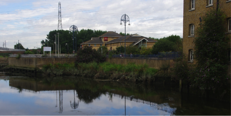
Figure 9: Mill Pool, River Roding, looking north west in Summer 2017 (11 years after construction). Source: Jacobs/TEAM2100.
4. Social, Litter, Safety and Navigation
4.1 Social
The site is not easily publicly accessible and therefore no social surveys were completed as part of this review.
4.2 Litter
A few pieces of litter observed but the terrace was generally clear (see Figures 7 and 8: No better photographs exist to demonstrate the lack of litter).
Contributing reasons for this include:
- Sheltered from both waves and currents and therefore no reason for litter to get swept in.
4.3 Safety and Navigation
This site has no signage or lights. In the event the area is frequented by craft, there is a risk that the sites lower levels could catch vessels and the proximity of lock entrance. Having reviewed the site in situ, it is now felt that warning to passing traffic, however infrequent, would have been beneficial.
5. Engineering
No official engineering assessment was able to be conducted at this site, but some improvements/refinements could be suggested:
Potential engineering improvements/ refinements
- Construct terraces from material with a longer residual life than timber.
- Provide greater depth of gravel/alluvium and drainage on terraces.
- Install established plants (rather than seeds).
6. Conclusions
6.1 Within the first 2 Years (2006 to 2008):
- Very poor establishment of Sea Club-rush and Common Reed after 1¼ years, but dense vegetation of tall species of London brownfield sites. Lowest tidal level dominated by Amphibious Bistort.
- Nearby ledges on the river supported good stands of Branched Bur-reed and Common Reed.
- Not clear why intended planting was unsuccessful.
- Poor aesthetic value for its setting.
- In 2008 it was suggested that a planting strategy with pot-grown riparian stock may have produced better results.
6.2 Within the next 10 years (2008 to 2018):
- Riparian vegetation has not improved and buddleia has taken over along one side.
- Accreted sediment remains in place due to low wave and current energy.
- Little litter has collected.
- Management of the vegetation that establishes naturally, removing unwanted species and leaving those which are valuable is now advised. Despite recent advice by engineers (above) and the 2008 guidance, it is recommended to allow natural establishment of vegetation. This is stressed in the sections on Wildlife Planting and Greenspace and guidance specific to intertidal vegetated terraces.
- Warning to craft would have been beneficial due to potential navigation hazards.